捷克佳博客

Jack JIA’s Online Database–一个用于新闻分析研究以及个人文章存档的场所。电邮:jackjia(a)gmail.com

Archive for 分类:安省高速公路

20100121/7号公路改名掀争议,反对者抨浪费金钱混淆公众

明报/针对把7号公路(highway 7)改名为“7号大道”(Avenue 7)的问题,约克区域政府刚于昨晚完成先后在万锦市、烈市及旺市进行的3场公众谘询,将会把收集到的意见写成报告,帮助区域议会作出决定。

昨晚在万锦市举行的公听会,是3场公听会中最后的1场,主持公听会的约克区政府官员表示,总结3场公听会,出席市民均表示支持7号公路改名,但是对于改为“7号大道”(Avenue 7)则有所保留。

约克区域政府昨日向本报称,他们将会把今次收集到的意见综合,写报告向区域议会汇报情况,从而有助区域议会作出有关决定。这份报告预期将在今年稍后、在夏季休会前提交区域议会。

7号公路建于1920年,已由早年的省级公路,逐渐演变成目前的市区主要道路,沿路已有更多的公车、商店及住宅大厦。区域政府考虑为它改名,就是为反映它已是一条现代市中心的大道。

除了万锦市议会已于2007年6月,考虑过改名的问题外,旺市也于同月通过动议,要求把该道路改名。至于在网上百科全书Wikipedia中,已把“7号大道”解作为建议中的新名字。

不过,不同意改名的人士,则批评改名计划浪费金钱,并且混淆公众。有区内居民指,用来更换新路牌的钱,将可更好用于修补及重铺该道路。也有居民认为无故改名会令人很混淆,跟向来以纪念故人或名人的做法不统一。

约克区当局如实施今次改名计划,将有约400个7号公路上的地址受影响,当中包括超过200个商户。但当局目前仍未有关于今次改名对当局、商户或居民的成本估计。

旺市商会总裁兼行政总监邦克(Deborah Bonk)则相信,改名的长期益处将会最终抵消其成本。她称,虽然她并不支持要花额外开支,但要改善旺市是要付出代价的,改名将可更配合日后沿路有新建的Metropolitan Centre及地铁站。

万锦市区域议员林歌顿(Gordon Landon)也称,该道路将来的规划,将会改变其公路的概念,变成是一条市区道路。沿路日后除了会被收窄外,还会降低车速上限,以及有更多的高楼住宅发展计划。

20100107/400系公路拥挤 行车需时倍增

404和400公路膺“最慢”榜首

明报/一项由安省交通厅于2008年完成的公路调查报告显示,大多伦多地区的上班族在路面交通所花的时间,比2006年要多出许多,尤其是在400系列的高速公路上,部分相同路段所需时间甚至已经翻倍。

该份名为“Travel Times”(驾驶时间)的调查报告中,404和400号公路膺“最慢公路”榜首,尤其以404公路由16街南向行驶至401公路路段情况最糟。而在早晨上班时段“十大最慢路段”中,401公路东向行驶的狄斯路(Dixie Rd.)与密西沙加路(Mississauga Rd.)路段之间,平均行驶速度,由2006年的每小时95公里减慢至2008年的50公里。

同样的,在410公路南向行驶的Bovaird Dr.与403公路之间路段,在早晨行驶的速度,亦由2006年的每小时71公里,跌至2008年的38公里。

根据该报告显示的一些其他数据,在所有被抽样调查的462个路段当中,有151处的结果显示都比两年前有所减慢,若与2002年相比,相同路程在2008年的行驶时间,普遍要多出13%至24%。

因此该报告建议,需驾车上班族要准备充足的时间,来应对缓慢的交通状况。

然而,该报告亦为多乘客乘坐的车辆司机带来一些好的消息,因为调查结果显示在403、404和401公路的多乘客车辆车道(HOV)的行驶速度,均比普通车道快许多。尤其是在403公路上东行方向的Winston Churchill Blvd.与401公路之间,在相同路程情况下要比普通车道快出6分钟时间。

此外,该报告还指出,约克区的主要路段行车状况要比皮尔区和多伦多地区好很多,但荣居最快行程榜首的地区依然为杜兰区。

安省交通挤塞持续加剧 151个路段情况显著恶化

星岛日报/帕斯(Peter Paz)每天从多伦多驾车前往纽马克(Newmarket)工作,促使他有机会看到是什么东西对交通情况造成严重影响。

帕斯表示:“我在过去11个月均从多伦多前往纽马克工作。每天朝着北面行车的时候,便可见到南行交通流量,它正在不断增加。当中大部分与约克区南面一带活动加强有关,原因很多公司的总部办事处正迁进该些地区。”

安省运输厅每两年更新一次的“行车时间调查”(Travel Time Study)数据显示,交通挤塞情况持续加剧。最新一次研究于2008年秋季进行。

介乎密西沙加道(Mississauga Rd.)与狄斯街(Dixie Rd.)之间最繁忙的一段401号公路(Highway 401),行车时间差不多增加一倍。

尽管受调查的多条高速公路路段之中,超过一半的行车时间并无明显分别,但另有151个路段在2006年与2008年之间出现显著恶化情况。

交通运输规划人员表示,包括增加更多公车服务在内的各项解决方案,它们的发展速度比不上交通挤塞的恶化速度。

对于在Smart Commute任职项目经理的帕斯而言,他并无机会选择乘搭GO火车上下班。所有GO火车班次在帕斯早上北上工作时均只是南行,情况到了下午则逆转。Smart Commute是一个致力鼓励人们采用各类交通工具而尽量避免自行驾车的机构。

调查数据并显示,高乘载车辆车道(HOV lanes)在部分地区能令行车时间缩短多达43%。省府现时正不断扩展HOV车道计划。

12高速公路路段有改善

运输厅辖下交通策划中部地区(Traffic Planning Central Region)办事处的尼科力(Gordon Nikolic)表示,统计数据亦包含一些好消息:上一次调查后进行过修路工程的12个高速公路路段均有所改善。

周末交通情况普遍良好,因此调查建议当局可以在周六及周日封闭更多行车线,藉以进行修路工程。

交通专家表示,交通挤塞是多伦多地区成功吸引新移居人士及行业的产物。

皮尔区首席规划师Margie Chung表示:“皮尔区人口在过去30年增加两倍,达到120万人。”

在多伦多,早上繁忙时段内,嘉甸拿高速公路(Gardiner Expressway)介乎京士维(Kingsway)与湖滨大道(Lake shore Blvd.)之间路段的平均行车速度仅为每小时22公里,但与2006年的每小时26公里比较,那只不过是温和下跌。

杜咸区及约克区主要干道的行车时间较多伦多及皮尔区更为优胜。

多市交通管理中心(Traffic Management Centre)总监斯托尼基(Roberto Stopnicki)表示:“我们不会在市内兴建新高速公路及道路,因此解决方法在于其他交通工具,亦即乘搭公车、踏单车、步行及合伙用车(carpooling)。”

根据“公共运输系统城市计划”(Transit City Plan),街车服务将延伸至各乡郊地区。斯托尼基表示,那是市府最显著的回应。他补充指出,市府每年投放300万元在科技上,促使交通灯号更能配合实际汽车流量。

但加拿大汽车协会(Canadian Automobile Association)的莱昂丝(Faye Lyons)表示,做法并不足够。她指出:“多伦多现时有大约2千个交通灯位,却只有3百个左右设置该种科技。当局需投放更多金钱。”

资料来源:星报

20100101/407公路下月加价,繁忙时段常规区每公里加1.5仙

明报/负责运营407电子收费公路的407 ETR公司昨日宣布,从2010年2月1日起,407公路的收费将有小幅度增加。

轻型车辆(包括普通汽车、小型客货车和SUV等),繁忙时段且在常规区(regular zone)的费用,将调高至每公里21.35仙(目前19.85仙);繁忙时段在轻度区(light zone)的费用调高至20.10仙(目前19.25仙);非繁忙时段调高为18.35仙(目前18仙)。

重型车辆如大卡车,繁忙时段且在常规区的费用将调高至每公里42.7仙(目前39.7仙);繁忙时段在轻度区的费用调高至40.2仙(目前38.5仙);非繁忙时段调高为36.7仙(目前36仙)。

繁忙时段指的是早上6时至10时,以及下午3时至下午7时。非繁忙时段指的是早上10时至下午3时,以及晚7时至凌晨6时,另外还包括法定节假日和周末。

常规区指的是介于QEW及Highway 410路段、Highway 427及Highway 400路段,以及Markham Road和Brock Road之间的路段。

轻度区指的是介于Highway 410及Highway 427路段,以及Highway 400及Markham Road之间的路段。

407 ETR公司主席Jose Tamariz表示,该公司打算在2010年投资超过7000万元,来修建20公里的新高速公路,及为现有路段提升,以减少交通挤塞。

从1999年以来,该公司已经投资12亿元,修建超过440公里新公路,以及其他道路提升。

市民如想了解此次加价的具体情况,可以上网www.407etr.com。

20090417/407高速公路首季赚800万

加通社多伦多电/多伦多北面407号收费高速公路的营运商407 International Inc.(TSX代号:SNC)周四透露,该公司在截至3月31日止的2009年首季度内录得盈利800万元。

去年同期,407 International Inc.亏损1,190万元。

季内收入由1.2亿元微跌至1.197亿元,该条收费高速公路的整体使用量按年计算亦轻微下跌,那可能是由于货车流量减少所致。

407 International Inc.拥有并且营运407号收费高速公路,该条高速公路在多伦多以北,由东至西全长108公里。

20090127/407高速公路将向东延伸,是否增收费用尚无定论

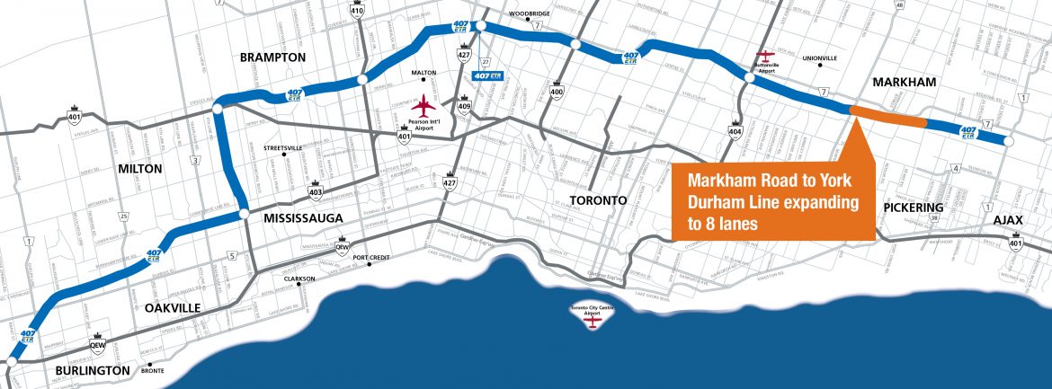
407公路扩建新段省府营运 4年后通车 未确定需否双重缴费

(多伦多27日加新社电)安省交通厅长布拉德利(Jim Bradley)周二宣布,省府将会扩建407收费公路,扩建的新路段将由省府营运,收入支付兴建成本和用作维修,但未知司机是否需要双重缴费。

反对党迅速指出,这个建议会令407公路向东延长至35/115公路,它是安省中部选区的主干道,保守党党领庄德利(John Tory),希望在这选区的补选中胜出。

布拉德利说,在宣布补选前作出上述宣布只是巧合,但庄德利说,他不相信。

布拉德利否认,这个宣布与争取选民支持有关。他说,延长407公路从皮克灵(Pickering)至卡拉灵顿(Clarington),预计2013年通车的建议,长期以来都在筹划当中。

布拉德利说,由私营公司拥有一条公路,自由党政府向来都“感到不安”。

407 ETR公司目前拥有和营运108公里长的407公路,向司机征收路费。

省府将负责这个扩建路段的收费事宜,但省府仍未确定,使用407公路的司机,是否要缴费两次。

假如一个司机使用私营路段和省府拥有的扩建路段,他有可能需要缴费给省府和407 ETR公司。但布拉德利说,仍未拟定这些详情。他说:“我们预期扩建路段的收入,属于安省政府,不是407 ETR公司的。”

他说,省府的收入会用来支付兴建成本和道路维修费用,这样可令省府腾出资金,用在公交基建项目。

该扩建工程现正进行环境评估,今夏将会提交环境厅长批准。

布拉德利不肯说,工程耗费多少,也不肯说省府是否计划,未来所有收费公路都由省府拥有。

Highway 407 to be extended
Jan 27, 2009
Maria Babbage
THE CANADIAN PRESS

Ontario will build and operate an extension of a privately run toll highway north of Toronto, but it’s not yet known whether drivers will face an additional charge to use it, Transportation Minister Jim Bradley said today.

The Opposition was quick to point out that the proposal would extend Highway 407 east to Highway 35/115 – the main artery in a central Ontario riding that Progressive Conservative Leader John Tory hopes to win in an upcoming byelection.

Bradley said it was just a coincidence that the announcement was made before the byelection is called, but Tory said he’s not convinced.

“I’m delighted that Mr. McGuinty is finally talking about Highway 407 again, and I’m sure it’s only because there’s a byelection coming up,” he said in an interview from Minden, Ont.

“I only wish he would get on with speeding it up.”

Bradley denied the announcement had anything to do with shoring up Liberal support with voters in Haliburton-Kawartha Lakes-Brock.

The proposed extension of Highway 407 from Pickering to Clarington, which is expected to open in 2013, has long been in the works, he said.

The Liberal government has “never been comfortable” with a private company owning a road in the province, Bradley said.

“There is dissatisfaction, I think, amongst the public with a private company owning the highway and having no control over the tolling of the highway,” he added.

“I think the public is much more comfortable with the province of Ontario owning a highway with the funds coming to the province of Ontario, as opposed to the private corporation.”

407 ETR currently manages and operates an existing 108-kilometre stretch of the highway and collects tolls from drivers.

The government will regulate tolls on the yet-to-be constructed extension of the highway, but the province hasn’t figured out whether drivers who use the 407 will have to pay twice.

If a driver were to use both the privately-operated stretch of highway and the government-owned extension, there is a possibility that the driver may have to pay the province and 407 ETR.

But Bradley said those details haven’t yet been worked out.

“Our anticipation is that the money, of course, that would come from the extension is money that goes to the province of Ontario and not to the 407 corporation,” he said.

Toll revenues collected by the province would go toward construction costs and maintenance of the road, he said, which would free up government money for transit infrastructure projects.

An environmental assessment is underway and will be submitted to the environment minister for approval this summer.

Bradley couldn’t say how much the project will cost and wouldn’t say whether the province plans to keep all future toll roads in public hands.

“Some may see it as a precedent and some may not,” he said.

407 International Inc., the sole shareholder of 407 ETR, is owned by a consortium comprised of Cintra Concesiones de Infraestructuras de Transporte, Macquarie Infrastructure Group and SNC-Lavalin.

In 1999, the former Conservative government under then-premier Mike Harris signed a 99-year lease to the private consortium to operate the highway, which was designed to bleed traffic from a badly congested Highway 401.

However, tolls soared and both the company and province were inundated with complaints about poor customer service, incorrect billing, and heavy-handed collection tactics.

相关新闻:

20071019/探访407高速公路总部

20090101/新年新例攸关安省省民福祉

加通社多伦多电/新年伊始,安省将实施一些新例新标准。

安省新屋由2009年1月1日起需符合一些新的能源效率标准。

自即日开始起,安省建筑规范规定所有新屋建筑的结构墙必需拥有接近全墙身隔热装置(near full-height insulation)。

新屋新能源标准实施

省府估计,该类房屋的能源效率一般会较10年前的房屋高出大约28%。

该项新规定是《2006年建筑规范》(2006 Building Code)引入三阶段能源效率方案的第二步骤。

到了2011年后,房屋需拥有“节能指引计划 80”(EnerGuide 80)水平或更高能源效率。

“节能指引计划 80”是由联邦自然资源部(Natural Resources Canada)发展及管理的房屋的模范能源评级制度。

之前新增的建筑规定主要针对窗户、天花板、墙壁及壁炉。

安省房屋厅长屈德逊(Jim Watson)表示:“我们新增的隔热规定将会有助兴建更清洁、更环保的社区。”

伤残员工福利增加

新年起,身受永久性伤害的安省员工领取的福利会稍微增加。

工作场所安全及保险局(Workplace Safety and Insurance Board)所支付的伤残福利从1月1日起增加2.5%,此项改变涵盖受到永久性伤害,以及身体部分残障的员工。

伤残福利在2007年7月及2008年元旦都有过相同的增幅,但直到2007年预算案时,伤残福利在先前的12年增加不到3%,元旦后的伤残福利则是在18个月内增加了7.5%。

407调高繁忙时段收费

使用407高速公路的驾驶人在2009年要付更多钱。

2月1日起,轻型车辆在交通繁忙时段的每公里收费增加0.6仙,为19.85仙,非繁忙时段的收费维持在目前水准。

除了行车里程的收费外,轻型车每次上407要付25仙,重型车50仙,牵引式拖车75仙。

讯号转发器的租金会减少10仙,未使用转发器而要照相的帐户收费也稍微减少。

经营407高速公路的407ETR声称,改变收费有助于维持交通顺畅及负担能力。该公司并表示,2009年要花费7,000万元用于新车道。

20080924/大多区拟耗500亿改造交通

盼75%居民可就近乘搭快速公车

【明报专讯】大多区交通机构Metrolinx昨天公布他们耗资500亿元、长达25年的大规模交通改善计划,其重点是集中发展公共交通。到25年计划完成时,大多区和咸美顿地区75%的居民,居所附近2公里就可搭乘快速公车。

Metrolink主席马基萨克(Rob MacIsaac)昨天表示,这是大多区过去50年来第一个扩大公共交通系统的大规模规划,将新建1150公里的包括地铁、电动街车等快速公共交通线路等,令每年搭乘公车的乘客人数翻一倍。

他表示,整个规划具备资金支撑,因此不会流于“纸上谈兵”。整个资金将分3个阶段,其中前2个阶段的资金已有安排,主要来自安省政府。第一阶段的资金总计约7.5亿元,是一批Metrolinx稍早前提出的“快速启动”项目,在安省今春的2008年预算中已获拨款。

第二阶段将从明年开始,使用安省“移动安省2020”计划中的拨款,用于大规模公共交通项目,资金总额约在17.5亿元。

第三阶段约从2015年起,资金尚无□落。不过,□时公共交通发展已经初显成果,大多区交通状况应有改善,届时再谈新增资金,应比较容易。

这个题为“大动作:改造大多区和咸美顿交通”的规划草案,共有8个“大动作”。

.一个快速、班次频繁的地区快速公交网络。该网络将以多伦多“公交城市”电动轻轨网络为基础,向大多区扩展;和GO火车双向、15分钟一班沿湖滨走廊奔驰。

.整合、连通区内主要城市中心的单车道和步行道路,单车道总长可达7000公里。

.一个全区交通信息网。可以让本区居民上网或通过电话了解实时交通信息,制定自己的出行计划。

.整合大多区和咸美顿的公交费用,实现智能卡全区一卡通。

.连接各个城市的交通枢纽,并进而连通邻里社区。

.从多伦多市中心联合车站,建立通往皮尔逊机场的快速公共交通,以及其他方向连到机场的公共交通线路。

.一个综合的物品运送策略。

.制定为本区交通系统提供稳定拨款的投资策略。

昨天发表的草案,在未来的2个月中,将广泛听取居民和各界的意见。

未来25年 涉资500亿 大多区交通发展大计

星报专讯/“都市连通”(Metrolinx)周二发表有关多伦多地区未来25年涉及金额500亿元的交通发展草拟计划,但所需资金从哪里而来却尚未弄清楚。

尽管该家大多伦多地区交通运输企划机构作出多项坚定承诺,但它在草拟计划中并没有建议当局征收道路使用费、交通挤塞费或其他税项,藉以帮补该项有助解决区内交通挤塞问题所需进行的扩大公车服务计划的庞大开支。

Metrolinx主席麦艾萨(Rob MacIsaac)表示:“不推行这项计划所涉及的成本比起推行计划还要大。我们不可被吓怕,逃避这项挑战。”

增添1150公里新捷运路线

有关计划包含100个特别项目,当中包括将士巴丹拿(Spadina)地铁站延伸至约克区、多伦多公车局(TTC)的“公车城市”(Transit City)街车网络、将GO火车电气化、扩展高速公路及开辟单车径等。根据计划,未来25年内将可增添1,150公里新的捷运路线。

该份名为“大行动:改善大多伦多及咸美顿地区交通运输”(The Big Move: Transforming Transportation in the Greater Toronto and Hamilton Area)的计划书将可确保75%居民生活在捷运系统的2公里范围内,高于现时的42%。

Metrolinx期望花费5亿元兴建7,500公里在道路上或在道路外的单车径,并希望在区内设立多个交通中心,供居民转乘不同类型的公共交通工具。

计划报告书仍需获得由11人组成的Metrolinx董事局于周五核准通过。之后当局会就各项建议进行公众谘询,最后才会向安省政府提交最后报告。

Metrolinx已向省府建议投放大约7.5亿元在多个所谓“迅速取胜”的项目上。它们预期会纳入春季发表的财政预算内。第二阶段计划为15个在总额175亿元MoveOntario 2020方案内的项目。第三阶段将紧随2013年进行的1次投资检讨,藉以研究2015年及以后的多个项目。

安省交通厅长布德利(Jim Bradley)表示,将会任由Metrolinx建议是否推出诸如征收道路使用费等增加收入的新措施。

但他指出,省府的一贯立场是无意向使用现有高速公路的驾驶者征收费用。布德利并且透露,不会作出超越2013年的拨款承诺。

TTC主席赞邦尼(Adam Giambrone)表示,很高兴看到所有计划中的7条“公车城市”街车路线均获周二发表的报告所认同。赞邦尼是Metrolinx董事局内4名多伦多成员之一。

促请联邦提供协助

同为Metrolinx董事局成员的多伦多市长苗大伟(David Miller)促请联邦政府站出来提供协助。

苗大伟表示:“情况十分清晰。多伦多地区使用公共交通服务的居民之中,超过80%使用TTC。若果TTC不继续扩充及发展,便难以符合地区需求。没有联邦政府参与其中,地区需求便不能达到。”

杜咸区议会主席安德逊(Roger Anderson)对于草拟计划书漠视杜咸区的交通发展感到愤怒。他尤其不快的是,尽管安省省长麦坚迪(Dalton McGuinty)多番保证,407号公路(Highway 407)会在未来5年内向东面伸延,但Metrolinx的有关报告并无作出任何承诺。

20071213/省府4亿助公车系统,多市TTC及GO公车受惠

星报专讯/安省政府周四将宣布对多伦多公车系统新增拨款4亿元,以帮助多伦多公车局(TTC)保持车队规模,并帮助GO公车系统扩展业务。

财政厅长邓肯(Dwight Duncan)今天下午将在省议会作此拨款宣布。这笔拨款中,3亿元将预留作安省公车系统,包括TTC,的维修费用。这只是自由党Move Ontario 2020计划承诺对大多地区公车系统拨款175亿元的第1个小部分。

此外,1亿元将拨给Metrolinx(1周前由大多市运输管理局GTTA改名而来),用于区域公车系统。

省府不等到2008年春季预算,而是选择现在作此宣布,是因为公车系统的改善属省府的优先项目之一 - 这些项目无需很大成本就可以很快起步。

这笔新拨款的宣布,离安省审计总长麦卡特(Jim McCarter)在其年度报告中批评GO公车局规划不善,仅2天时间。他周二批评称,历年来,拥挤和延误的情况日趋恶化,并称当局没有对设备故障给予足够的重视。

助建大多交通网络

给Metrolinx的拨款将帮助构建一个连接多伦多、杜咸(Durham)、约克、皮尔(Peel)、荷顿(Halton)及咸美顿的交通网络。其中,6,000万元用于GO公车系统购买20列双层火车车厢,来扩充繁忙的湖滨(Lakeshore)走廊的运输力。

900万元将用于购买10辆双层巴士,改善407公路-403公路走廊,以及约克大学线的服务。有消息称,这是未来的407公路东西快车的前奏。

此外,还有2,000万元用于GO发展迅速的布拉福德(Bradford)和史托维(Stouffville)线上的双轨部分。这将提供多伦多和万锦,及多伦多和纽马克(Newmarket)和基林堡(Gwillimbury)间的全天双向火车服务。

还有560万元用于万锦Cornell公车站新站台的建设,以将VIVA系统和GO、约克区公车及杜咸区公车系统相连。

最后的550万元将为咸美顿Upper James走廊购买6辆新式的柴油电气混能巴士。这将造福咸美顿国际机场、Mohawk学院及市中心终点站周围的乘客。

20071020/401高速公路最宽的一段有多宽?

不愧为世界上最繁忙的高速公路之一,401高速公路最宽的一段双向行车道多达18道,也是自己每天上下班的必经之路。画面上横跨的桥梁为Dixie Rd。

hwy401_18lanes_w.jpg

下图为采用主辅道(Express-Collector Lanes)系统的401高速公路。
hwy401_cross_section_w.jpg

20071019/探访407高速公路总部

(星星生活特稿/捷克佳)对407高速公路(407 ETR)来说,2007年10月14日是一个特殊的日子,因为这一天是407开通10周年的纪念日。作为庆祝活动的一个组成部分,经营及管理该条高速公路的407 ETR公司,在10月期间,对公众开放总部办公室,以便让人们有机会了解这个世界首条全自动收费公路是如何运营的。

hwy407overlook.jpg
(407高速与400高速立交桥)

几经电邮联系,终于约定在16日下午前往407 ETR公司总部参观。总部位于6300 Steeles Ave. W.,负责接待的是公关部经理戴尔-艾柏斯(Dale Albers),本以为是数人组成一个团体参观,但实际上只有自己一个人,自然也就多了一些与艾柏斯的交流机会。


(公关部经理艾柏斯在客户服务中心告示板前介绍)

407高速公路的全称是407快速收费高速路(407 Express Toll Route,简称为407 ETR)。这是大多伦多地区唯一的一条收费公路,从西南的伯灵顿(Burlington)至东部的皮克林(Pickering),总长108公里。

作为安省400号高速公路系列的一条主干道,最初的规划和兴建主要是考虑为东西走向的401高速公路舒缓交通流量。401高速路是世界上最为繁忙的公路之一,其在穿越多伦多市区的部分区段427高速路与404高速路间,每日的交通流量超过50万车次。

就在10周年前几天的10月5日(周五),感恩节长周末,407高速公路录得建成以来破纪录的单日最大车流量445,822。407的极限流量与401的平均流量虽然不可同比,但这也侧面验证407的分流实力和潜力。


(在交通监控室里,雷内-冈萨雷斯(Rene Gonzalez)正在全神贯注地监控407高速公路主要交通点的状况。在这里他写下自己的名字,几个字母上面带撇,没有看懂,只好让他再写一遍,总算能按字母认出他的名字)


(交通监控室也被人从外面“监控”)

事实上,由于401公路在上世纪六十年代后期的拓宽极为成功,当时便已设计成型的407高速公路直到1987年才开始动工兴建,并在1997年10月14日正式开通计费。407高速公路一个突出的特点是这是世界首条开放式全自动收费公路,进出高速公路既没有收费站,也无需停车,收费方式采用图像识别系统和电子收发装置(Transponder)混合计费。

有关公路收费是一个由争议的话题。十九世纪30年代初期,政府在多伦多最为繁忙的央街开始征收通行费,直至后来在1896年取消省内所有道路的收费。官员当时发誓,今后将不会再收费。省政府将通过征收入息和汽油税来解决这一问题。但在一个世纪之后,政客们抛弃了曾经的诺言。1997年407高速公路的开通使收费公路再次重返舞台。这次只是披上个高科技的马甲,美其名为407 ETR。

在兴建407高速公路的过程中,安省政府一直备受资金短缺的困扰。1990年,从自由党手中夺得政权的新民主党李博(Bob Rae)担任安省省长一职,资金问题更为突出并一度停工。为了加速建设470公路,李博政府在1993年决定公私合营,在省府的监督下,将该条公路作为收费公路由一家私营公司经营,为期35年。407公路终于在1997年6月7日试通车,并在当年10月14日正式开通。

/** 题外话:翻开历史档案,贯穿期间的几任安省省长分别是由自由党皮特森(David Peterson, 任期 1985-06-26—1990-10-01),新民主党李博(任期 1990-10-01—1995-06-26),和保守党的夏里斯(Mike Harris, 任期 1995-06-26—2002-04-14)。皮特森比安省现任保守党领袖庄德利(John Tory)还要惨,前者作为执政党的省长在选区败选,后辞职,后者是作为反对党党魁在选区败选,仍在位,两人均在安省选举中创造另类奇迹。在加国政坛上,李博是至今为止唯一担任东部省份省长的新民主党成员。后来他转投自由党,并在2006年获联邦自由党提名竞选党魁,但不敌狄安(Stephane Dion)。**/

在1999年,夏里斯领导的前安省保守党政府为化解财政债务,以99年的租期将407高速公路私有化,租约以31亿元交易售予一间跨国私人财团,令该条公路成为加国首条私营收费公路。目前,407高速公路也被认为是北美地区首条在经济上获得成功的私人经营的收费公路。


(位于6300 Steeles Ave. W.的407 ETR公司总部外景)


(在407 ETR公司1999年从安省政府接手之初,只有这一个服务台六个柜口)

407 ETR公司公关部经理艾柏斯颇为自豪地说,正是由于私营,407高速公路的建设比原规划提前20年完成,而且公司在接手后原有68公里里程的基础上,自筹资金,又将407延伸40公里,并在多个区段拓宽道路。他说,公司内部客户服务中心的改善,技术设备的更新,以及道路的维护保养,公司投入大力的财力。

在近14000平方英尺的客户服务中心,可以看到工作人员正在紧张地忙碌中。艾柏斯介绍说,这里的工作人员分为四个级别,最高的一级躲在后面的小房间中。呼叫中心提供包括中文(国语和广东话)在内的十余种语言的服务。他说,在整个公司500余员工中,呼叫中心是人数最多的一个部门。目前有150 余名工作人员,通话线路超过600条。而在1999年时,这里只有21名员工,21条通话线路。


(紧张忙碌的客户服务电话呼叫中心一景)

根据艾柏斯提供的资料,呼叫中心的电话接听在2005年下降29%,2006年又再度下降14%,这主要是公司网站增加了更多的在线服务内容。艾柏斯指着墙上的布告板说,昨天(15日)客服呼叫中心共回答3336个电话,这是上一天的工作业绩。在另一面墙上,透过投影仪打出不断变化的数字则是当天来电和回答的实时境况。

在交通监控室里,雷内-冈萨雷斯(Rene Gonzalez)正在全神贯注地监控407高速公路主要交通点的状况。坐在大屏幕前,可以同时监测18个交通摄像镜头传回的画面。从桌子上的电脑中也可以看到通过GPS定位系统确定的各类服务车辆当前的位置。冈萨雷斯说,比如在冬天铲雪,或救援抛锚的车辆,确定这些服务车辆的位置十分重要。

随后参观的是公司的系统监控室,这里是整个公司的中枢,如果那里的摄影头发生故障,那里的电子线路出现问题,在系统监控室这里便能及时发现。之后参观的是公司的计算机中心,也是一个不小的部门,不过看起来员工好像挺轻松,可以扎堆聊天聊地聊人间,一幅歌舞升平的景象,与电话呼叫中心比起来,两个部门截然不同。


(系统监控室是整个公司的中枢)


(轻松的计算机中)

而后参观的另外一个部门牌照鉴证部门更绝,20多人的房间竟然没有一个人。公关部经理艾柏斯说,可能这个时间大家都去休息喝咖啡(Coffee Break)。他拿出一张印有牌照的纸张解释说,为避免人为的错误,抄录牌照的程序之一是“双盲操作”(Double blind process),即须经两个人确定后才能出账单。他说,对这个部门的要求是,决不猜测,宁可损失金钱,也决不可将账单寄错人。

目前,因无需计费和不能判读而没有入账的比例只占交通流量的3.8%,前者包括紧急救援,道路维护,和获得免费授权的车辆等,后者包括那些无牌照,或牌照被遮挡,以及因恶劣天气如雪或雾等因素无法辨别造成的呆帐。

艾柏斯介绍说,407公路的照相系统是采用自然光源,牌照鉴证部门有专门的处理软件去判读车牌,而不是那种依靠瞬间闪光照相去捕捉记录车牌,因此,“不要指望在车牌上喷反光漆,就能逃掉过路费,那是在浪费自己的金钱。”他说。

20071017/行在红枫王国——加拿大的道路安全见闻

文献:《新安全》2003年 8期


401国道监控控制中心

■ 张巍汉 何 勇 摄影/何 勇

加拿大位于北美洲的北半部,国土面积997万平方公里,人口约3100万。作为一个经济高度发达的国家,加拿大同时也是世界上交通安全情况最好的国家之一。

加拿大政府的秉承“以人为本,生命重于泰山”的安全理念,采取教育、道路安全立法、预防与整治并重的交通安全策略,取得了令人瞩目的成果。在2001年度,加拿大(不包括魁北克)全年死于交通事故的人数只有2778人,而同时期我国的交通事故死亡人数达到了10.6万人。笔者曾有幸对加拿大进行了学术访问,考察了加拿大交通安全措施,并与加拿大的同行一起讨论了交通安全问题,深深感到我国在交通安全水平上与加拿大的差距远不止数字上体现的那么简单。下面就介绍一下笔者在加拿大关于交通安全的一些感想和所见所闻。

良好的交通安全意识

交通安全问题包含人、车、路、环境四个方面,其中,作为整个环节中的主体-——人(驾驶员和其它道路使用者)的素质与安全意识在交通安全中起着重要作用。通过全民交通安全教育和道路安全立法,加拿大人普遍具有较高的交通安全意识。

根据笔者的观察:加拿大的驾驶员每当驾车到设有“停车让行”标志的道路交叉口,都会自觉地停车,左右观望,确定安全后才通过,如有过往行人和车辆,都是让行人和其他车辆先行后自己再通过;在设置信号灯的交叉路口,不管交叉道路上有车无车,红灯时驾驶员都自觉停车,没有盲目闯红灯的。即使在深夜车辆很少的时候也是如此。而开车前系好安全带则更是加拿大驾驶员的习惯。这与我国抢行和不喜欢系安全带的普遍状态是一巨大的反差。

另外,加拿大对弱势道路使用者和特种车辆如儿童和公交巴士给予了较高的道路优先使用权,且全社会共同遵守。学校的校车和公交巴士均拥有优先通行权或专用的行车道,即使在交通堵塞的时候也不会有其它车辆占用。当车内载有幼儿的时候,加拿大人会在车上贴上“车内有幼儿“的标识,而其它驾驶员会主动为他让路,以保证幼儿的舒适与安全。

加拿大人的这种全民交通安全意识是其交通事故率低的重要原因,而这也正是我国与交通安全状态好的国家的最大差距。这种差距不是短时期内便能弥补的,需要我国交通安全从业人员和教育、立法等多个部门长期共同的努力才能得以改善。

成熟的交通管理系统

加拿大的公路交通管理系统和城市交通管理系统基本上都由交通部门控制。不同的是:高速公路的交通管理系统偏重于交通堵塞的控制和交通事故的紧急救援;城市的交管系统则主要对城市重要路段的交通状况和各种交通行为进行实时监视与远程控制,确保安全和畅顺。

根据加拿大同行的介绍,加拿大安大略省交通部在重要的高速公路干线上均设置了名为“指南针”的交通监控系统。照片1就是加拿大401国道“指南针”系统指挥监控中心的一角。可以看到:它没有国内一些高速公路监控中心壮观,但是它的功能却非常强大,这都源于监控外场设备的高密度设置。在401高速公路上,为了管理每天高达37.5万辆的交通量,该高速公路上的“指南针”系统在55Km的路段上设置了74部外场摄像机、2996个检测线圈、30多处门架式可变情报板,由监控中心对采集到的交通数据进行实时处理并采取必要的交通控制措施。真正做到了对运输状况的全程监控和实时控制。该系统可以在十几秒的时间内自动判断交通事故的发生并确定事故发生的具体地点,同时由外场摄像机传回现场图像以及时判断事故类型和严重程度,可变情报板及时发布交通事故信息,引导上游车辆提前离开高速公路以避免大规模交通堵塞。同时,配备的紧急救援系统立刻启动,一般在30分钟的时间内可使交通完全恢复正常。建立这样庞大的一个交通监控系统自然花费不菲,但是根据加拿大政府的统计分析,“指南针”系统在401国道上的应用每年可获得超过三千万美元的回报,减少三十万小时的交通延迟和200起交通事故,交通高峰期的交通流流动速度提高了7%~19%,由此带来的能源、环境、经济和社会效益是难以计量的。

首都渥太华市的交通管理监控中心由当地政府交通部门负责管理,类似于国内的城市交通监控系统,该系统由路口摄像机、交通信号标志控制器、地感线圈、传输线路和监控中心的显示及控制终端等构成点、线、面结合的立体交叉监控体系,主要完成对城市地区各敏感路段(甚至全路段)的交通状况和各种交通行为的实时监视,包括交通量统计、信号灯联动控制、违规行为记录等应用。另外,各种交通管理设施的远程控制的职能也由城市交通管理监控中心完成。根据城市的实时交通状况发布合适的交通控制命令,从而达到统筹调度、快速响应,维护交通畅通和安全运行的目的。照片2就是渥太华城市交通管理监控中心的操作平台。这个交通监控中心的规模并不大,值班的操作人员也只有三、四名,但是通过高度自动化的系统软件和足够数量的外场设备,渥太华的城市交通状况要比国内的大部分城市要好的多。

渥太华的这种城市交通监控模式在加拿大甚至在整个北美都是非常具有代表性的。与国内情况不同的是,国内大部分地区的城市交通监控系统是由当地的交通执法部门(通常为交通警察部门)建立和管理的;而加拿大的这种城市交通监控机构与其交通执法部门是相互独立的,它们在行政职能上是彼此独立、互相支持、互相监督的。监控中心随时与警察部门、救护部门和新闻机构保持密切联系,为他们提供需要的任何交通数据,并提供紧急状态下的交通控制服务。

另外,笔者在还参观了407国道上设置的世界上较为先进的 “电子不停车收费ETC”系统。该系统由车载器、自动读卡器和中央控制系统构成,在车辆高速通过读卡器的时候就可以完成收取通行费的全部手续。因此,不需要设置占地很大的收费广场,也不用设置很大规模的加减速车道。不但缩短了收费时间(近似于零),提高了通行能力,而且还减少了车辆的加减速和交织,有效提升了道路的交通安全水平。

完善的交通事故预防体系

从交通工程学科的角度来说,交通事故的预防主要是消除道路本身的交通安全隐患和提高车辆在紧急情况下的反应性能,另外,完善的道路安全立法也是一个重要方面。

为了消除道路本身的交通安全隐患,加拿大政府在道路交通建设中采取的一项有效措施是实行道路安全评价制度。研究表明:约1/4的交通事故是因“人与道路/环境”不协调引发的。道路安全评价就是一种避免这种“不协调”的预防策略,它以保障道路使用者安全为中心,从预防交通事故、降低事故产生的可能性和严重性入手,对道路项目建设的全过程,即规划、设计、施工和服务期进行全方位的安全评价,从而揭示道路发生事故的潜在危险因素及安全性能,是国际上近期兴起的以预防交通事故和提高道路交通安全为目的的一项新技术手段。道路安全评价是由公正独立、有资质的人员对涉及使用者的道路项目(已建或将建)进行的正式审查,以确定对道路使用者任何潜在的不安全特性或构成威胁的运营安排。其目标是:确定项目潜在的安全隐患;确保考虑了合适的安全对策;使安全隐患得以消除或以较低的代价降低其负面影响,避免道路成为事故多发路段;保障道路项目在规划、设计、施工和运营各阶段都考虑了使用者安全需求,从而保证现已运营或将建设的道路项目能为使用者提供最高实用标准的交通安全服务。

上个世纪八十年代末英国就率先开展了道路安全评价工作,澳大利亚、新西兰在九十年代早期,加拿大、美国在九十年代中后期都普遍推行了道路安全评价制度。目前,意大利、新加坡、马来西亚、南非、丹麦、荷兰、香港等国家和地区都开展了这项工作。

国外研究表明,道路安全评价可有效地预防交通事故,降低交通事故率及严重程度,减少道路开通后改建、完善和运营管理费用,提升交通安全文化。根据已开展安全评价的国家统计,安全评价的回报率是投资的15~40倍!

先进的交通事故黑点改造体系
  
加拿大对交通事故“黑点”的改造十分重视。值得注重的是:除政府部门之外,加拿大的保险公司都设立专门的部门和专项资金用于道路“黑点”的改造。根据保险公司的统计:只需要很少的投资即可以很好的改善道路安全水平,大幅度地减少保险理赔金的数额。

在具体实施中,由大量有专门资质的咨询公司参与提供技术服务,采用交通冲突分析等手段确定事故“黑点”的成因,并提出具体的改造措施。

但是,事故“黑点”路段往往不具备彻底对道路线形进行改造的经济条件和社会条件。此时,一般采用有针对性的交通工程手段包括交通控制和交通诱导来解决道路的安全问题。下面就是一处道路黑点改造的例子,两照片显示的分别是进行改造前后的情况:

该路段为一长直线接一急弯下坡,弯道前正对直线还有一处小路口,通车后频繁发生交通事故,主要事故类型为车辆冲出弯道。主要原因是因为长直路段车速很快,而且因为障碍物的影响使驾驶员对急弯路况估计不足。因此加拿大工程师确定的改造原则为:封闭支路;控制车辆进入弯道时的速度;对平曲线线形给予充分的诱导。具体措施为:封闭小路口,该路口车辆从别处绕行;在路口处栽植诱导性高大树木,设置醒目的防护栏和警告诱导标志;在进入弯道前的直线段提前设置警告、限速、禁止超车标志及减速标线;该路段设置中心双黄线;设置照明路灯及反光突起路标等。采取上述措施后该路段未再发生交通事故。

上面对加拿大道路交通安全的介绍只是冰山之一角,但也令人实实在在的感受到了加方以人为本、安全、服务和可持续发展的交通理念和加拿大人谦让、守法的交通安全意识和交通道德。作为世界上最早构筑道路的国家之一,国内至今仍没有一家权威机构负责交通数据历史资料的管理和分析,所能获取的资料其连续性、完整性和客观性等都难尽人意。我国至今还没有制订国家道路安全目标和道路安全策略,在道路研究、规划和设计中重建设、轻安全的行为时时可见,这些不都是我们的差距所在吗?希望我们能以其它交通发达国家为镜,确实提高我国的交通安全水平,与我国人口大国和交通大国的国际地位相适应。

作者单位:交通部公路科学研究所交通工程部


工作人员在监控中心值勤


动态自动称重站


改造前的情况


改造后的情况


不用停车就可收费的电子读卡装置

http://www.people.com.cn/GB/paper2515/10121/927247.html

20071017/安省407高速公路历史回顾

Highway 407 ETR - www.OntHighways.com

Highway 407 is Ontario’s newest, and without doubt most controversial 400-series highway. The highway stretches from the QEW/403 interchange in Burlington easterly around Toronto to Highway 7 just east of Brougham. The highway is operated privately by a consortium of companies known as Highway 407 International. This consortium has leased Highway 407 for a term of 99 years, and generates its revenue through toll collection. Tolls are collected electronically, allowing Highway 407 to operate as a ‘barrier-free’ highway, free of toll-booths. For more information on Highway 407 and for tolling information and rates, please visit Highway 407’s Official website.

——————————————————————————–

Western Terminus: At the Freeman Interchange in Burlington, junction Highway 403 & QEW

Eastern Terminus: Highway 7 near Brougham in the City of Pickering

Length: 108.08km

Multiplexes: None

Freeway: Entire Length. (38 interchanges)

Tolling Rates: Tolling information and rates are available from Highway 407’s official website here

Road Info: Highway 407 is maintained impeccably well (as it should be considering the expensive tolls). Congestion is rare along the highway as Highway 407 International has been very aggressive in widening the highway to keep pace with steady traffic growth. Like most other 400-series highways in Ontario, Highway 407 has a posted 100km/h speed limit.

——————————————————————————–

History of Highway 407:

Planning for this highway first started in the 1950s when traffic congestion first crippled Highway 401 through Toronto. The extensive reconstruction of Highway 401 through Toronto to a 12-lane facility deminished the need for Highway 407 until congestion again slowed Highway 401 to a crawl throughout much of the GTA in the 1980s. In the late 1980s construction started on the first stage of Highway 407 which at that point was to run from Highway 427 in western Vaughan to Highway 7 just east of Centre Street in Thornhill. Due to budget constraints work was halted during Bob Rae’s term as Ontario’s premiere, and the highway was re-evaluated. In order to speed up construction in 1993 the Rae government sought to construct Highway 407 in conjunction with the private sector. The highway was to be operated as a toll road for a 35 year term by a private company under the supervision of the Ontario government. This public-private partnership allowed construction to progress much quicker then had been previously possible, and on June 7th, 1997 the first stretch of Highway 407 opened from Highway 410 to Highway 404. Unfortunately this opening was plagued with problems, the highway was opened six months behind schedule amid serious safety concerns. Problems also delayed tolling, which didn’t begin until October 14th, 1997. This delay was due to apparent problems with the all-electronic tolling system.

On December 13th, 1997 the first extension was opened to traffic from Highway 410 westerly to Highway 401 near Winston Churchill Boulevard. The first easterly extension opened in opened on February 18th, 1998 from Highway 404 easterly to McCowan Road in Markham. On September 4th of that same year another westerly extension opened which saw Highway 407 extended to the Highway 403 interchange in Mississauga. The last extension to be completed under the then-current lease-agreement was opened to traffic on June 24th, 1999 between McCowan and Markham Roads in Markham. The opening of this stretch of highway had been delayed since 1998 due to concerns of added traffic through Markham village along Highway 48.

Later in 1999, details of the lease were significantly changed, giving much more control to the operators of Highway 407. As part of this agreement, the lease was extended from 35 to 99-years, and the government lost all rights to regulate toll increases. As part of this deal, the operators of Highway 407 were contractually obligated to complete the west extension to the QEW, and the east partial extension to Highway 7 east of Brougham. The west extension was originally conceived as part of Highway 403 and was to by-pass the QEW to the north of the urban portions of Oakville and Burlington. This stretch of highway opened in three stages between June 7th, 2001 and July 18th, 2001. The east extension was completed roughly three moths ahead of schedule and opened August 30th, 2001. Three major lane widenings have taken place since that time to keep pace with traffic demands. Highway 407 was widened from six to eight lanes between Highways 427 and 400 in 2003, and was widened from four to six lanes between Highways 401 and 10 in the summer of 2004. During the 2005 and 2006 construction seasons the Central section of Highway 407 between Highways 427 and 404 was widened from six to eight lanes. Advance work is also ongoing to widen the portion of Highway westerly from Highway 427 to west of Highway 410. This work will likely be completed during the Fall of 2007.

Presently the MTO is in the planning stages of extending Highway 407 east from Brougham to the junctions of Highway 35 and 115 at Enterprise Hill. No construction timetables have been established for this highway, and construction is likely at least a decade away since this stretch of highway has been stalled in the environmental assessment stage.

http://www.onthighways.com/highway_407.htm

20071017/安省400系列高速公路网

400-Series Highways (Ontario)
From Wikipedia, the free encyclopedia

he 400-series highways are a network of controlled-access freeways throughout the southern portion of the province of Ontario, Canada, forming a special subset of the provincial highway system. They function similarly to the Interstate Highway network in the United States or the Autoroute system in the province of Quebec. Modern 400-series highways have high design standards, speed limits of 100 km/h (62.5 mph), and various collision avoidance and traffic management systems. 400-series highway design has set the precedent for a number of innovations used throughout North America, including the Parclo interchange.

Contents

1 400-series network
2 400-series numbering
3 Paving Surface
4 Standards for 400-series highways
5 List of 400-series highways
5.1 Highway 400
5.2 Highway 401
5.3 Highway 402
5.4 Highway 403
5.5 Highway 404
5.6 Highway 405
5.7 Highway 406
5.8 Highway 407
5.9 Highway 409
5.10 Highway 410
5.11 Highway 416
5.12 Highway 417
5.13 Highway 420
5.14 Highway 427
5.15 Queen Elizabeth Way
6 Former 400-series highways
6.1 Highway 400A
6.2 Highway 401A
6.3 Queen Elizabeth Way east of Highway 427
7 Future additions to the system
7.1 Mid-Peninsula Highway
7.2 Highway 424 (Brantford to Cambridge)
7.3 Bradford Bypass
7.4 407-401 Durham West Connector
7.5 407-401 Durham East Connector
8 References
9 See also
10 External links

400-series network

For their entire length, 400-series highways are intended to be completely controlled-access and divided, with a minimum of four lanes. Although the 400-series freeways currently form a network around Highway 401 and the QEW, this has not always been the case (such as Highway 417 until 1999) and being part of a network is not a requirement as it has been for US Interstates. Like the Quebec Autoroute system, 400-series highways have been expanding slowly because they did not benefit from regular federal funding.

The province also maintains freeways which are up to 400-series standards, yet are not numbered as part of the 400-series network. This is despite some of those freeways exceeding existing 400-series highways in size and traffic volume and despite some of them being connected to the 400-series network. Nonetheless, Ontario freeways do not receive a 400-series number unless they are designed to be complete controlled-access freeways for their whole length. While at-grade intersections still exist on Highways 400 and 406, planning/construction is underway to upgrade them to full freeway standards. The non 400-series routes listed below have significant open-access portions besides the freeway section, with the freeway segment typically being a small section not at the route’s termini.

Most prominent is the Conestoga Parkway in Kitchener-Waterloo, which is numbered in 3 sections; Highway 7/8, Highway 7, and Highway 85, and the Highway 8 Freeport Diversion between Highway 401 and the Conestoga. The E.C. Row Expressway in Windsor, Ontario was numbered as part of Highway 2 before the freeway was downloaded to municipal authorities in 1998. Other examples of non 400-series numbered freeways in the provincial inventory are at Thorold (Highway 58), Peterborough to Enterprise Hill (Highway 115), North Bay and southward (Highway 11) and Sudbury (Highway 17, though it is possible that the long-term expansion of Highway 417 could incorporate that freeway section of Highway 17).

400-series numbering

The “400-Series” numbers were first introduced in 1952 to designate the province’s controlled-access highways. The “4″ was intended to reflect that these were four-lane roads, although portions of these highways subsequently exceeded four lanes.

Although the Queen Elizabeth Way has no posted highway number, it is considered to be part of the 400-series highway network. In fact, the QEW was the first of the controlled-access highways to be constructed. The Ontario Ministry of Transportation designates the QEW as Highway 451 for internal purposes; this designation never appears on maps or highway signs.

400-series highways receive numbers one of two ways. The original method was sequential numbering starting at 400 and working up to 409. The first three 400-series highways numbered accordingly were Highway 400, Highway 401 and Highway 402 — originally known as the Barrie-Toronto Highway, Highway 2A and the Blue Water Bridge Approach. Since then, additional highways have been constructed using sequential numbering from 403 to 409. Although there were plans for a Highway 408 it was never constructed. It is speculated that the new Mid-Peninsula Highway bypass of the Queen Elizabeth Way will receive the designation 408. Highway 407 (now 407 ETR) received its designation in the 1960s when it was planned and land was acquired for it, although construction did not start until 1987.

The later method of 400-series numbering after 1970 was to assign a 400 designation to an upgrade or bypass of an existing highway. For example, part of Highway 427 was the original routing of Highway 27 between the QEW and Highway 401 prior to being upgraded to a freeway, while 427 is a bypass of 27 north of 401. Highway 416 and 417 were the original routings of Highway 16 and 17 respectively, in eastern Ontario. Note that in order to qualify for 400-series numbering, the freeway upgrade starts at the terminus of the existing route. If the freeway upgrade is in the middle (not at the termini), then the route retains its original number unless one of the open-access termini is decommissioned. Sometimes the highway is not necessarily an upgrade of the existing route. Highway 410 and 420 were both freeway bypasses of Highway 10 and Highway 20. Highway 424, once constructed, will be a freeway bypass of Highway 24.

The province’s baseline standard for the construction of a 400-series highway (or any controlled-access freeway, whether numbered as a 400-series or not) is an average traffic count of 10,000 vehicles per day. However, other factors are considered as well. To promote economic development in a disadvantaged region (e.g. current construction extending Highway 400 to Northern Ontario), a 400-series highway may be built where the existing highway’s traffic counts fall below 10,000. As well, for environmental, budgetary or community reasons, some proposed 400-series highways have not been built even where an existing highway’s traffic counts exceed the standard. A good example includes the cancelled Highway 400 extension from 401 to the Gardiner Expressway in the 1960s (a portion was revived as the Black Creek Drive expressway in 1982, which was built by the province and then immediately downloaded to the city).

Highway 401 is spoken as “four-oh-one” and Highway 427 is spoken as “four-twenty-seven”. Highway 400 is pronounced “four-hundred”.

Paving Surface

400 series freeways show many similar design aspects to the USA Interstate Highway system. One major difference between USA and Canadian highways are the pavement surfaces. While the USA defaults to using concrete as a wearing surface, Ontario defaults to asphalt as a wearing surface.

The majority of all 400 series highways are coated with asphalt pavement, though some sections are receiving concrete pavement, such as Highway 401 from Windsor to Tilbury. Exceptions among 400-series highways include Highways 406, 407 ETR and 427, which all have significant portions built in exposed concrete. All 400-series highway bridge decks are also covered with asphalt, with concrete only exposed around the expansion joints, unlike US Interstates where most bridge decks are exposed concrete with tining (grooves) to add traction in wet weather.

The reasoning behind Ontario’s large use of asphalt is based on this explanation from Alfred Ho, at the Ontario MTO (Ministry of Transportation) website:

Asset durability has always been one of our prime concerns in management of bridges and other long term assets. For our Canadian harsh winters with ice and snow on our highway, we use de-icing salt, and a lot of it. Although it is good for the travelling motorists who can have a better grip for the road, it does terrible damage to the concrete components of our highways system; In particular bridges where the embedded reinforcing steel would corrode and rust. To protect the steel from the ingress of chloride ions from the salt solution, we placed a layer of rubberized asphalt waterproofing on all of our bridge decks. And to protect this waterproofing, 2 lifts of asphalt are placed on the bridges. We have good corrosion protection results over the years; and we have confirm the results with studies. Again thanks for you interest, and you are most welcomed to visit and use our highway system first hand. Alfred Ho Alfred Ho, P.Eng., MBA MTO Central Region

Conversely, Alfred’s email can be argued from a recent e mail shown below from an Illinois Department of Transportation engineer who disputed the Canadian way of paving bridge decks:

Asphalt bridge surfaces observed in Ontario incorporate the philosophy of a wearing surface. The intention is to periodically replace this relatively inexpensive thickness of asphalt before deterioration to prevent exposure of the more cost-intensive concrete deck, superstructure, and substructure portions of the bridge to the damaging effects of the environment and vehicular traffic.

As logical as this philosophy may appear, a few drawbacks do exist.

1. Wearing surfaces can range between two and four inches in thickness, creating additional weight the structure is required to support. This in turn increases the overall design of a structure, translating into additional expense.

2. The wearing surface will be less durable than the concrete bridge deck, requiring more frequent repairs and maintenance. Routine schedules for replacement of the sacrificial layer require strict adherence as delays can invalidate decades of careful planning. Interruptions to free-flow traffic with more frequent work-zones also has a negative overall impact on level of service, translating into lost productivity time as the public are subjected to increased periods of congestion.

3. No guarantees are available even if maintenance schedules are followed with rigid discipline. IDOT is committed to ensuring the roads are clear and safe regardless of weather conditions, translating into a large quantity of salt use for ice prevention. This practice has a negative effect on the life-expectancy of the infrastructure as corrosion becomes more prevalent.

As shown above, Ontario MTO and Illinois DOT engineers have many factors to consider when it comes to pavement in dealing with snow, ice and salt in the very similar climates of Toronto and Chicago. This explanation can be proved first hand from any drive within the Greater Toronto Area or Chicago area. The majority of bridge decks and pavement in Toronto (Canada) are asphalt while in the Chicago (USA) area, most highways are continuous concrete highway/bridge deck or combo asphalt pavement/concrete bridge deck arrangement.

Standards for 400-series highways

This article does not cite any references or sources. (September 2007)
Please help improve this article by adding citations to reliable sources. Unverifiable material may be challenged and removed.

Here is a list of highway construction standards required. These are similar to standards for other controlled-access highways systems such as the AASHTO Interstate Highway standards.

-At least two lanes in each direction.
-If HOV lanes are used, they must be separated from general traffic with a striped buffer zone and full shoulder.
-Opposing direction is to be separated by grass median, usually of sufficient width to prevent cross-directional collisions, to provide drainage, and may allow for future expansion.
-If a grass median is not feasible, an “Ontario tall-wall” concrete barrier should be installed. The tall wall is based upon the Jersey barrier but is not reinforced and higher at 1070-mm.[1]
-100% grade separated crossings
-A design speed of at least 130 km/h (80 mph), although the posted speed on signs is 100 km/h - exceptions can be made for urban areas where a 130 km/h design speed cannot be realistically implemented such as Highway 403 through Hamilton (90 km/h) and Highway 406 through downtown St. Catharines (80 km/h).
-Unless there are land space constraints, 4-way junctions should be a parclo interchange when it meets with a surface road.
-There is no standard for freeway-to-freeway junction as it depends upon traffic volumes, only that there must not be any traffic weaving when merging onto each road. This makes interchanges such as the cloverleaf not up to 400-series standard.
-Advanced warning signage for junctions at 2 km (1.2 miles), 1 km (0.6 miles) and 500 m (1650 ft) before the junction
-Right-hand side on-ramps and off-ramps. Exceptions to this rule do exist, however.
-Acceleration/deceleration lanes from interchanges must be at least 150 meters long to allow for smooth speed increase/decrease and traffic merging, unless there are land space constraints.
-Full-width left and right paved shoulders
-Rumble strips on each side of the carriageway
-Standard 400-series highway signage, uniform across the entire system.
-Road-side advertisements (e.g. billboards) are banned from the right-of-way of 400-series highways. The province has also obtained court orders forcing the removal of advertising signs that are outside of the highway corridor, but adjacent to and still visible from, a 400-series highway (such as along nearby farms close to the freeway). This ban exists to prevent driver distraction.
-Standard directional signage is white-on-green, with collector lanes using white-on-blue to distinguish between mainline (express) and collector signage.
-Based on the precedent set by Highway 407 ETR, any future toll roads constructed will also need to have white-on-blue signage.
-Separated high-occupancy vehicle lanes use black-on-white signage with a diamond logo in the upper left-hand corner.
-A 400 meter or longer “weave lane” is required for transitions to/from HOV lanes across the buffer zone to allow for safe mergers.
-Service/attraction signage is white-on-blue, though older brown-on-white signs still exist.
-Caution signage is black-on-yellow.
Construction (temporary conditions) signage is black-on-orange
-Square lane deviation signs, notifying drivers approximately 1 km prior to their lane leaving the highway. These signs are unique to Ontario.

Many 400-series highways have also recently had gates installed at entrance ramps, along with special gated ramps located near overpasses, allowing access to the highway to be easily closed in case of emergency or road work. In some cases, different standards applied at the time of construction and have been grandfathered to the system. This is most prominent on Highway 400, Highway 401, and the Queen Elizabeth Way, whose low standard sections are only upgraded when growing traffic conditions warrant a major reconstruction. Although some highways receive a 400-series number right away, they are not built to 400-series standards until construction of the highway is completed.

List of 400-series highways

There are 15 different 400-series highways (including the QEW) creating a transportation backbone across the southern portion of the province. Plans are currently underway to extend the existing network into Northern Ontario as well as add new routes into the system.

Highway 400

The Canadian Shield is mostly exposed along Highway 400For more details on this topic, see Highway 400 (Ontario).

229 km in length (extensions planned northward to Sudbury); actual highway 209 km in length - 2nd longest 400-series highway.
Year: 1952 (known as the Barrie-Toronto Highway prior to 1952)
Southern terminus: Maple Leaf Drive overpass in Toronto
Northern terminus: Bowes Street/McDougall Drive in Parry Sound, where it continues as Highway 69
Planned northern terminus: Highway 17 in the southeast part of Sudbury
As of October 2003, Highway 400 runs from Toronto to Parry Sound. There is currently an 8 km (5 mile) gap at the Wahta Mohawk Territory where this highway is only two lanes, rather than four; however, as the four-lane construction is expected to be completed in 2007, the Highway 400 designation has already been extended through this segment. There is also an approximately 20 km stretch, from Horseshoe Lake to the terminus at Parry Sound, where the highway bears the dual designation 400/69. At the Parry Sound terminus of Highway 400, the four lanes simply merge into two and continue northward as Highway 69. Continued construction along the Highway 69 corridor will eventually extend Highway 400 to Sudbury in Northern Ontario. Although this may be subject to change, the Ontario Ministry of Transportation currently plans to have this construction completed by 2017.
Highway 400 is Toronto’s main freeway link to York Region, Barrie and Muskoka.

Highway 401

Highway 401 was completed just west of Brockville in 1968For more details on this topic, see Highway 401 (Ontario).

Named the Macdonald-Cartier Freeway for its entire length in 1965
Named the Highway of Heroes for its length between the Don Valley Parkway in Toronto and Trenton in honor of Canada’s fallen soldiers in Afghanistan in 2007.[1][2]
817.9 km (508 miles) in length - the longest 400-series highway
Year: 1952 (known as Highway 2A prior to 1952)
Western terminus: Highway 3 in Windsor
Planned Western terminus: A new international bridge crossing into Downriver Michigan.
Eastern terminus: Quebec Border (Autoroute 20)
Highway 401 runs from Windsor to the Quebec border. Highway 401 is the backbone of the 400-Series network running across the entire length of Southern and Eastern Ontario. The unique Macdonald-Cartier Freeway signage has been slowly disappearing over the past 10 years.
Highway 401 has volumes of over 500,000 per day in some areas of Toronto, making it the current record holder as the busiest highway in the world.[3]

Highway 402

For more details on this topic, see Highway 402 (Ontario).

102.5 km (64 miles) in length
Year: 1952 (known as the Blue Water Bridge Approach prior to 1952)
Western terminus: Blue Water Bridge in Point Edward
Eastern terminus: Highway 401 in London
Highway 402 starts at the Blue Water Bridge in Point Edward (a small village located inside Sarnia) and runs 102 km to end at Highway 401 in London. The 402 connects Interstates 69 and 94 in Michigan with the 401 in Ontario.
Initially, Highway 402 terminated at Highway 40, and commuters continued east to London via Highway 7. In 1972-1982, Highway 402 was extended to meet up with Highway 401.

Highway 403

For more details on this topic, see Highway 403 (Ontario).

Known as the Chedoke Expressway through Hamilton.
112.4 km (70 miles) in length, of which 23 km (14.3 miles) of which are concurrently signed with the Queen Elizabeth Way (400-series co-signing is rare)
Year: 1963
Western terminus: Highway 401 in Woodstock
Eastern terminus: Highway 401 in Mississauga
Highway 403 is one of two freeways with a dedicated High Occupancy Vehicle Lane patrolled 24/7 (Highway 401 to Highway 407)
Highway 403 forms a loop that runs from the Highway 401 in Woodstock back to the junction of Highway 401 and Highway 410 in Mississauga. It passes through Brantford, Hamilton, and Mississauga. Land that was originally planned to be used for the 403 through Burlington and Oakville was leased to the owners of Highway 407 in the mid-1990s, making a 23 km gap between the two sections permanent. In 2002 the Ministry of Transportation co-signed the section of QEW between Burlington and Mississauga together with Highway 403.
The Mississauga portion of Highway 403 was intended to be redesignated as part of Highway 410 (which continues it northwards after the major interchange with Highway 401) after it was decided that the Mississauga-Hamilton gap would be built as the toll Highway 407 instead of being a 403 extension. However, the Ministry of Transportation later rejected the idea, as it was decided that it might confuse some people accustomed to the original number which had been in use since 1982.
Highway 403 has been assigned exit numbers in recent years from Woodstock to Brantford, with the remainder of the highway to have its exits numbered in the near future.

Highway 404

For more details on this topic, see Highway 404 (Ontario).

36.8 km (22.9 miles) in length (extensions planned northward)
Year: 1977 (known as the extension of the Don Valley Parkway prior to 1977)
Southern terminus: Highway 401 in Toronto
Northern terminus: Herald Road/Green Lane in East Gwillimbury
Highway 404 is 1 of 2 highways with dedicated 24/7 High Occupancy Vehicle Lanes (Highway 7 to Highway 401/Don Valley Parkway) and is the only one with a dedicated HOV off-ramp (Highway 401 Westbound)
Highway 404 runs from north from the junction of Highway 401 and the Don Valley Parkway in Toronto and ends currently in Newmarket, with eventual plans to extend it to the northern side of Lake Simcoe. Highway 404 is the second north-south freeway in York Region and connects the northeastern suburbs and into Toronto as the Don Valley Parkway. Highway 404 is expected to be extended to Keswick around 2010, at York Regional Road 32, Ravenshoe Road. Further extension to Highway 12 in Pefferlaw is planned.

Highway 405

For more details on this topic, see Highway 405 (Ontario).

Named the General Brock Parkway for its entire length in 2006
8.5 km (5.3 miles) in length
Year: 1963
Western terminus: Queen Elizabeth Way west of Niagara Falls
Eastern terminus: Lewiston-Queenston Bridge with the United States
Highway 405 serves as a connector from the Queen Elizabeth Way to the Queenston-Lewiston Bridge in Queenston. Though a short spur route, it is still considered a major highway connecting the main trunk highway to Toronto (the QEW) with Interstate 190 outside of Niagara Falls, New York.

Highway 406

For more details on this topic, see Highway 406 (Ontario).

25 km (15.5 miles) in length (extensions planned southward)
Year: 1965
Southern terminus: East Main Street (Highway 7146) in Welland
Planned southern terminus: Mid-Peninsula Highway (probable Highway 408) connection near Port Colborne
Northern terminus: Queen Elizabeth Way in St. Catharines
Highway 406 serves as a north-south route from the Queen Elizabeth Way through downtown St. Catharines and into central Niagara. It is the last remaining 400-Series highway under Ministry of Transportation jurisdiction with two-lane non-freeway sections, located between Thorold and Welland. Extending the four-lane freeway south of the former Highway 20 will start in 2006. Plans to extend the route further south to the Mid-Peninsula Highway have been voiced, although the status of the project is uncertain in the face of continuous delays in the Mid-Peninsula project.

Highway 407

For more details on this topic, see 407 ETR.

108 km (67 miles) in length (extensions planned)
Year: 1997 (although 407 received its designation in the 1960s)
Western terminus: Junction of Highway 403 and the Queen Elizabeth Way in Burlington
Eastern terminus: Highway 7 near Brock Road in Pickering
Planned eastern terminus: Highway 35/115 at Enterprise Hill, or junction of Highway 7 and Lansdowne Street in Peterborough
Highway 407 forms a northern bypass for Highway 401 and the Queen Elizabeth Way through the Greater Toronto Area. It is Ontario’s only toll highway. Owned by Cintra, a private corporation, it is not officially considered part of the King’s Highway system, however it was originally designed to be a part of the provincial highway network. Highway 407 received its designation in the 1960s but due to the success of the Highway 401 widening, construction did not start until 1987. The reason for the privatization of Highway 407 is that the Ontario Government started running low on funds set aside for the project so they looked for corporate assistance. Highway 407 was also the first highway to use electronic toll collection exclusively for its entire length. An easterly extension to Highways 35/115 between Peterborough and Clarington has been suggested, however, this phase is in the planning stages.

Highway 409

For more details on this topic, see Highway 409 (Ontario).

Formerly known as the Belfield Expressway
4.4 km (2.7 miles) in length
Year: 1975
Western terminus: Airport Road in Mississauga
Eastern terminus: Highway 401 in Toronto
Highway 409 is a short connector route from the 401 to Toronto Pearson International Airport. A short section of Highway 409 between Airport Road and Highway 427 in Mississauga was sold to the Greater Toronto Airport Authority in 1999 and is now under their jurisdiction.

Highway 410

For more details on this topic, see Highway 410 (Ontario).

13.5 km (8.4 miles) in length (extensions planned and under construction northward, will be 21 km long when the current construction is completed)
Year: 1979
Southern terminus: Highway 401 in Mississauga
Northern terminus: Mayfield Road in Brampton
Highway 410 runs from the junction of Highway 401 and Highway 403 in Mississauga through Northern Mississauga and Brampton, with eventual plans to extend it as far north as Orangeville or Owen Sound. Construction of a short extension from Highway 7 to Highway 10 is currently under way. This highway does not use exit numbers, although it likely will in the future when extended farther.

Highway 416

For more details on this topic, see Highway 416 (Ontario).

Known as the Veterans Memorial Highway for its entire length
75 km (46.6 miles) in length
Year: 1996–2000
Southern terminus: Highway 401 north of Johnstown and the Prescott-Ogdensburg Bridge
Northern terminus: Highway 417 in Ottawa
Highway 416 runs from Highway 401 near Johnstown to Highway 417 near Bells Corners in Ottawa. South of Manotick-North Gower, it follows the former routing Highway 16.
On the 54th anniversary of D-Day, June 6, 1999, Highway 416 was officially dedicated as the Veterans Memorial Highway. It is the newest 400-Series highway to be built and owned by the Ministry of Transportation and is the main link (via the 401 and I-81) between the US and Canada’s National Capital Region. It was officially completed on September 23, 1999.

Highway 417

For more details on this topic, see Highway 417 (Ontario).

Part of the Trans-Canada Highway
Known as the Queensway through most of Ottawa
182 km (113 miles) in length (extensions planned westward)
Year: 1971
Eastern terminus: Quebec border (Autoroute 40)
Western terminus: Arnprior where it continues as Highway 17
Highway 417 is the main freeway through the National Capital Region and Eastern Ontario along the Quebec border. Construction of a 17 km extension to Arnprior was completed on September 24, 2004. Eventually the Ministry of Transportation hopes to extend the 417 through the Ottawa Valley; however, there is no definite timeline set for this construction. (There is a new 29-km stretch of 4-lane Highway 17 freeway under construction east of Sault Ste. Marie that is scheduled to open in 2008, and likely to have exit numbers in the 900s should it ever be connected, and an existing freeway segment in Sudbury.) Unlike most other east-west highways in Ontario, the 417 begins its mileage logs at the eastern terminus rather than the west.
Mile By Mile: Highway 417 - Trans Canada Highway Quebec / Ontario Border to City of Ottawa

Highway 420

For more details on this topic, see Highway 420 (Ontario).

3.8 km (2.4 miles) in length (extensions planned westward)
Year: 1972 (known as the Queen Elizabeth Way prior to 1972)
Western terminus: Queen Elizabeth Way in Niagara Falls
Planned western terminus: Highway 406 at St. Catharines/Thorold
Eastern terminus: Stanley Ave in Niagara Falls, where it continues to the Rainbow Bridge as Regional Road 420.
This short freeway connects the QEW to the tourist district in Niagara Falls. The Highway 420 designation used to continue for nearly 800 meters east of Stanley Ave, and this section was just a regular four-lane city street known as Roberts Street. Though this section of highway was once considered part of the 420, it was transferred to the City of Niagara Falls in 2000, and is now known as Regional Road 420. In the medium term, the Ministry of Transportation hopes to extend the 420 west past Montrose Road to meet up with Highway 58 and the Thorold Tunnel. However, progress has been stalled due to the uncertainty of the proposed Mid-Peninsula Bypass.

Highway 427

For more details on this topic, see Highway 427 (Ontario).

Formerly known as the Airport Expressway between Highway 401 and Highway 409.
21.3 km (13.3 miles) in length (extensions planned northward)
Year: 1972 (known as Highway 27 between the Queen Elizabeth Way and Highway 401 and as the Airport Expressway between Highway 401 and Highway 409 prior to 1972)
Southern terminus: Evans Ave in Toronto
Northern terminus: Highway 7 in Vaughan
Planned northern terminus: Highway 400 north of Barrie
Highway 427 came into existence by designating the already-freeway portions of Highway 27 and the Airport Expressway as a 400-series highway. It serves the heavy-travelled area between the Queen Elizabeth Way and Gardiner Expressway in the south and Highway 407 in the north. Highway 427 has heavy traffic volumes and is no less than 12 lanes between the Queen Elizabeth Way/Gardiner Expressway and Highway 401. The Ministry of Transportation plans on extending Highway 427 to at least Highway 400 north of at least Highway 89, and eventually into the Barrie area.

Queen Elizabeth Way

For more details on this topic, see Queen Elizabeth Way.

139 km (86 miles) in length
Year: 1939
Fort Erie terminus: Peace Bridge in Fort Erie
Toronto terminus: Highway 427 in Toronto, where it continues as the Gardiner Expressway
The Queen Elizabeth Way (QEW) is one of North America’s oldest long-distance superhighways. Due to several directional changes along the route the highway uses city names rather than cardinal directions to direct motorists. The QEW is not referred to by a route number, unlike the other 400-Series highways, but it does have the internal designation of Highway 451 and is considered part of the 400-Series highway network. Unlike the Highway shields for other Highways which are white, the QEW’s shield is gold.

——————-

Former 400-series highways

Due to government restructuring in 1997 and 1998 various sections of provincial highway were transferred over to local jurisdictions. While most of the highways transferred were local in nature, several large routes including freeways were transferred to local governments.

Highway 400A

For more details on this topic, see Highway 400A (Ontario).
Status: Now a section of Highway 11
Length: 1.1 km (0.7 miles) in Length
Year: 1960-1997
Western Terminus: Highway 400 in Barrie, Ontario
Eastern Terminus: Highway 11 in Barrie, Ontario
Highway 400A, though never signed, was a short spur connecting Highway 400 to the Highway 11 expressway northeast of Barrie. It was initially part of Highway 400 until 1960 when a new section of Highway 400 opened, bypassing 1.1 km of freeway which was re-numbered Highway 400A. When Highway 11 south of Highway 400 was transferred to local control in 1997 the designation Highway 11 was officially applied to Highway 400A, eliminating it in its entirety.
Highway 400A was formerly the shortest 400-Series Highway and had no junctions located between its termini.

Highway 401A
For more details on this topic, see Dougall Parkway.
Status: Now Municipally-Maintained “Dougall Parkway”
Length: 3.0 km (2.0 miles) in Length
Year: 1952-1997
Western Terminus: Highway 3B (Howard Avenue) in Windsor, Ontario
Eastern Terminus: Highway 401 in Windsor, Ontario
Highway 401A was never signed, much like Highway 400A above. It was the original alignment of Highway 401, from 1952 until 1964, when it was re-routed to connect directly to Highway 3. Many maps would show it and Highway 401, signed as both Highway 401 and Highway 3B, much to the confusion of map-readers, since the freeway would split into two directions. It was downloaded to the City of Windsor in 1997, and was in horrible shape. It has since been completely repaved, and a partial interchange was added at Sixth Concession Road to help improve access to and from South Windsor.
Although Highway 3B was decommissioned in 1975 (being downloaded to the City of Windsor), it maintained a “Connecting Link”, allowing road maps to still list it as Highway 3B, and for the city to receive some assistance in maintaining the road. This Connecting Link (found across the province as a small yellow square with “C/L” on a sign) was removed in 1997, making the requirement for Highway 401A extinct as a provincial highway.

Queen Elizabeth Way east of Highway 427
For more details on this topic, see Queen Elizabeth Way.
Status: Now a section of the Gardiner Expressway
Length: 6 km (3.8 miles) in Length (total QEW length 145 km)
Year: 1939-1997
Western Terminus: Highway 427 in Toronto, Ontario
Eastern Terminus: Gardiner Expressway in Toronto, Ontario
This short section of Queen Elizabeth Way was transferred to the City of Toronto in 1997 as a cost savings measure by the Provincial Government. It has since been re-designated as a western extension of the Gardiner Expressway.

———————–

Future additions to the system

This article contains information about a planned or expected future road.
It may contain information of a speculative nature and the content may change as the road’s construction or completion approaches and more information becomes available.

There are several plans on the books to add new routes to the 400-series highway system to serve the growing population of motorists throughout Ontario. Some of these new routes may be toll roads owned and operated in a similar fashion to Highway 407. In addition, the long-term extension of Highway 417 towards North Bay (and beyond), as well as construction of a staged freeway on the Highway 11 corridor, would likely absorb the existing freeway sections of Highway 11 and Highway 17 into 400-series highways.

Mid-Peninsula Highway

For more details on this topic, see Mid-Peninsula Highway.
Designation not yet determined, speculated to become Highway 408
Year: No firm dates have been established; timelines varying from 10 to 30 years until completion have been quoted.
Planned Western Terminus: Highway 407 in Burlington, or Highway 401 near Milton
Planned Eastern Terminus: Queen Elizabeth Way in Fort Erie, Ontario
The Mid-Peninsula Highway will serve as southern bypass of the Queen Elizabeth Way through the environmentally-sensitive Niagara Peninsula. Current estimates indicate that the QEW will require five lanes of traffic per direction by 2012. Widening the highway to ten lanes through Ontario’s Wine Country and Tender Fruitlands was not considered an acceptable option due to increasing development pressure. Instead, the Mid-Peninsula Highway was devised as a bypass of the QEW for traffic heading directly to Toronto and across the southern and central portions of the Niagara Peninsula. The Mid-Peninsula Highway will more than likely be a privately-owned toll road (it has been speculated that it will be built and run by the operators of Highway 407).[citation needed] It is a highly controversial project as it will likely run through tender agricultural areas and the Niagara Escarpment as well, and many question the need of the highway. Some sections of the project may face cancellation, as some land owners have refused to sell land for the highway’s construction.

Highway 424 (Brantford to Cambridge)
For more details on this topic, see Highway 424 (Ontario).

Officially designated as Highway 424
Year: 2010s
Planned Southern Terminus: Highway 403 in Brantford, with the possibility of a further southward extension into Norfolk County
Planned Northern Terminus: Highway 401 in Cambridge
A new freeway alignment of Highway 24, to be called Highway 424, has been part of the Ministry of Transportation’s plans for Brant County and Waterloo Region since the 1970s. Although constantly delayed, civic leaders in the region have recently begun to lobby the provincial government to begin construction of this route. In late March 2005, the provincial government announced that an environmental assessment has begun, and that construction should begin by the end of the decade.

Bradford Bypass

For more details on this topic, see Bradford Bypass.
No designation determined at this time, but may receive a designation of 413, 414, 488, or simply be extensions of 404 and 427
Year: 2012
Planned Western Terminus: Highway 400 near Bradford, or Highway 427 near Bond Head.
Planned Eastern Terminus: Highway 404 near Queensville
The Bradford Bypass will serve as a connector between Highways 400 and 404 on the extreme northern edge of the Greater Toronto Area. Construction is expected to begin by the end of this decade.

407-401 Durham West Connector

For more details on this topic, see 407-401 Durham West Connector.
Designation not yet determined, speculated to receive Highway 412
Year: Initial construction in the mid-2010s, to be finished no later than 2035.
Planned Southern Terminus: Highway 401 on the Ajax/Whitby border
Planned Northern Terminus: Highway 407, just east of the new Pickering Airport
The 401/407 Durham West Connector will serve as a connector between Highway 401 and Highway 407 in the fast-growing western end of Durham Region. Plans for this new freeway will see it located near Lake Ridge Road between Ajax and Whitby. There is no 401 interchange at Lake Ridge Road, but one is proposed to open there in the future. With the recent announcement of the development of Pickering Airport, the Durham West Connector will play an even greater role in the area’s transportation network.

407-401 Durham East Connector

For more details on this topic, see 407-401 Durham East Connector.
Designation not yet determined.
Year: Initial construction in the mid-2010s, to be finished no later than 2035.
Planned Southern Terminus: Highway 401 in Clarington, in the community of Courtice
Planned Northern Terminus: Highway 407
The 401/407 Durham East Connector is a planned connector that will serve the east end of Durham Region, including Oshawa and Clarington. The alignment will be located east of Courtice Road in Clarington.

References

^ City News
^ CTV.ca
^ Ministry of Transportation (Ontario) (6 August 2002). Ontario government investing $401 million to upgrade Highway 401. Retrieved on 2006-12-20.

See also

List of Ontario expressways
List of Ontario provincial highways
100-Series Highways of Nova Scotia
Quebec Autoroutes
Cameron Bevers, The History of Ontario’s Kings Highways at http://www.thekingshighway.ca/
Scott Steeves, www.ONTHIGHWAYS.com at http://www.onthighways.com/

External links

Wikimedia Commons has media related to:
400-series highways (Ontario)Ontario Ministry of Transportation
Database of Ontario Provincial Highways
VEHICLES ON CONTROLLED-ACCESS HIGHWAYS, R.R.O. 1990, Reg. 630
History of Ontario’s Highways
Photographs of Ontario Highways
Photographs and history on the 400-Series Highways (and other provincial highways, too)

http://en.wikipedia.org/wiki/400-Series_Highway

20071017/安省407高速公路的历史与现况

Highway 407 (Ontario)

From Wikipedia, the free encyclopedia

Highway 407, officially called the 407 Express Toll Route (ETR), is a tollway located in the Greater Toronto Area, southern Ontario, Canada. It begins at the junction of the Queen Elizabeth Way and Highway 403 in Burlington, and travels 108 km east to its present terminus at Highway 7 and Brock Road (Durham Regional Road 1) in Pickering. Plans are currently underway to extend the highway further east through Durham Region, eventually ending at the junction of Highway 35 near Orono.

Sold to a private consortium in 1999, Highway 407 was formerly planned as a 400-series provincial freeway designed as a bypass of Highway 401, the main truck route through Southern Ontario and one of the world’s busiest highways with well over 400,000 average daily trips on a section between Highway 427 and Highway 404.

Major freeway junctions with Highway 407 are located at (from west to east) the Queen Elizabeth Way, Highway 403, Highway 401, Highway 410, Highway 427, Highway 400 and Highway 404. Other major street junctions include Bronte Road (Halton Regional Road 25), Hurontario Street, Highway 27, Yonge Street and Markham Road (Highway 48). Overall there are 40 different junctions on Highway 407 connecting the toll road with the main transportation network in the Greater Toronto Area.

Contents

1 Unique characteristics
1.1 Description
1.2 Safety concerns
1.3 Plate denial – The process
2 History
3 Future of the 407
4 Billing
5 Tolls
6 Lane configurations from west to east
7 Exit list
7.1 Proposed
8 407 East Extension
9 Fleet
10 Facilities
11 See also
12 References
13 External links

Unique characteristics

The 407 uses a system of cameras and transponders to toll vehicles automatically. There are no toll booths, hence the name “Express Toll Route” (ETR). Highway 407 is designed as a normal freeway with interchanges connecting directly to surface streets, without the need for toll booth intermediaries (typically via a trumpet interchange) which could otherwise take up significant land. A radio antenna detects when a vehicle with a transponder has entered and exited the highway, calculating the toll rate. For vehicles without a transponder, an automatic number plate recognition system is used. Monthly statements are mailed to users. The 407 is the world’s first highway to feature this system throughout.

Description

The original section of Highway 407, between Highway 410 and Highway 404, is one of the better-designed freeways in the province of Ontario because of its recent design.

It was the first highway in almost thirty years since Highway 427 to be surfaced with concrete instead of asphalt, which despite involving a costlier initial investment, lasts significantly longer and has better reflective capabilities (although motorists have a noisier ride). Unlike most American concrete highways where the concrete is a continuous surface on both roadway and bridge surfaces, all 407 bridge decks are covered with an Ontario styled asphalt wearing surface to save weight. Also, some sections of the 407 are paved with asphalt instead of concrete since these sections opened much later (QEW (west termisus)-403; Markham Road-Highway 7(east terminus). It also has a high-pressure sodium high-mast lighting system installed throughout the length of the freeway; only 4 lamps are needed instead of the usual 8-12 since the concrete pavement reflects light better than asphalt. The 407 (along with other recent suburban and rural Ontario freeways) has been designed with aesthetics in mind, with landscaped embankments and storm drainage ponds at interchanges.

Because of its wide median, it has the capacity to be expanded from six to ten lanes (maximum of eight lanes through Thornhill) without having to reconstruct existing bridges and interchanges.

Braided ramps were used to avoid weaving when there were closely spaced interchanges. Interestingly, as Highway 400 northbound approaches Highway 407, 407 is Exit 26 despite the fact that it crosses Highway 400 at kilometre 28. Had it been designated Exit 28, northbound traffic would pass Exit 28 before Exit 27 (Steeles Avenue), since the ramp to the 407 leaves the 400 so far in advance of the junction. Such a situation would be more likely to confuse drives than the chosen alternate solution, which was to designate Highway 407 as Exit 26

The high-capacity junction with Highway 400 is considered one of the best-designed interchanges and it is currently the only 4-level stack in Ontario. Another 4-level interchange with Highway 427 also has the capacity to be expanded to a stack if traffic levels warrant.

Safety concerns

When the freeway was opened in 1997, many critics complained that it had skimped on safety features to save money. Many of Highway 407’s shortcomings were documented in an independent study which included input from the Ontario Provincial Police. The four-way interchanges with Highway 410 and Highway 404 were intended to be four-level stack interchanges but they were reduced to three-level stack/cloverleaf junctions, with low-capacity loop ramps serving freeway-to-freeway traffic (only the interchange with Highway 400 was built as a four-level stack, while Highway 427 is expected to be converted to a stack when the highway is extended north). Experts were also concerned about the decreased loop ramp radii and a lack of protective guardrail at sharp curves. The lack of a concrete median barrier separating the carriageways has also been a worry, considering the high traffic volumes typical of a suburban freeway and because the lighting masts are installed in the median instead of the shoulder. It was argued that the large grass median separating the carriageways was sufficient to prevent cross-over collisions, since Highway 410 has similar features. Most of these concerns were dismissed on the grounds that it would require an extensive reconstruction of the existing freeway.

Since the lease of the highway’s operation, there has been a noticeable decrease in design standards, including straight-sided overpass structures (rather than the sloped design common on most provincial highways), the conversion of dual exit lanes to an exit lane and an additional travel lane in Mississauga rather than paying to widen the carriageway and maintaining two exit lanes, the reduction of the central median and the use of temporary concrete barriers rather than maintaining the median width, and the use of asphalt paving rather than concrete on the Burlington to Mississauga and Markham to Pickering sections. The freeway still adheres to minimum provincial government highway safety standards, although the MTO themselves regularly exceed their own standards.

Inadequate signage leading to 407 has been criticized for being misleading, with motorists incurring bills for accidentally driving onto the 407. Further controversy has centred on the westward extension from Mississauga to Burlington; despite the majority of traffic not using that section of Highway 407, the interchanges at the ends are nonetheless designed with that segment as the mainline through traffic. While this design would have been well-suited to the original design, which was intended to be used for an extension of Highway 403, this no longer applied when it was redesignated 407 and the private operators merely recycled original designs. Because most current Ontario freeways are designed with right-hand exits (while through traffic stays on the left), left-hand exits to the 407 have caused a great deal of confusion with cases of drivers unintentionally driving onto 407 from eastbound 403.

The 407 is operated privately under a 99-year lease agreement with the provincial government. The lease was sold to a consortium of Canadian, Spanish and Australian interests operating under the name 407 International Inc. for approximately 3.1 billion Canadian dollars in 1999. Highway 407 is believed to be the first financially successful privately operated toll road in North America.

Plate denial – The process

Following a judicial decision by the Ontario Divisional Court on November 7, 2005, the Ontario Registrar of Motor Vehicles was ordered to begin denying the validation or issue of vehicle permits for 407 ETR users who have failed to pay owed fees for at least 125 days. On November 7, 2005, Ontario’s Transportation Minister Harinder Takhar said in a press release, “That is very serious… when it occurs through no fault of their own, but because the 407 ETR electronic system made a mistake.” [1]

On November 24, 2005, the MTO announced that it would appeal the decision but would begin to deny plates until the appeal was decided.

On February 24, 2006, the Ontario Court of Appeals denied the government leave to appeal the November 7, 2005 decision. As a result, plate denial is once again in place.

Previously, in February 2000, the Ontario government would suspend driver licenses for unpaid 407 bills; however, this practice was quickly suspended by the Ontario government and the new owner of the highway after receiving many complaints from customers about erroneous billing. Between 2000 and 2005, the company said it improved its billing system to minimize the chance of plate denial errors.

The Highway 407 Act, Section 22, gives the owner of the 407 ETR the ability to deny the plate renewal of drivers who have refused to pay their tolls for 125 days or more. Before the 407 can notify the Registrar of Motor Vehicles to deny plate renewal or refuse to issue a new plate for a driver, the Highway 407 Act specifies how this process would work.

According to the Highway 407 Act, Section 13(1), the 407 can only charge drivers under two conditions: the name of the person whom the plate portion of the vehicle is issued to, or the name of the person whom the transponder unit affixed in the vehicle is issued to. If a driver enters the 407 and does not have a transponder in his or her vehicle, the 407 snaps a picture of the license plate and receives information about the person to whom the plate is registered, including the name and address, from the Ontario Ministry of Transportation. The 407 would then mail a bill to the address that is on file at the Ministry of Transportation. Drivers will have 37 days from the billing date on the statement to pay their tolls.

As the 407 ETR does not implement in a timely fashion the updates it receives from the Ministry of Transportation about a driver’s contact information, the 407 ETR may send bills to an address where the driver no longer resides, resulting in accumulating charges without the driver ever seeing a bill.

Notice of Failure to Pay

If a driver has a 407 bill that is outstanding for more than 37 days, the 407 ETR will mail a “Notice of Failure to Pay” to the address they have on file for that driver without attempting to verify it. At this point outstanding accounts will start accumulating interest (26.82% APR, compounded monthly). Additional administrative fees may also be charged on the account. If a driver receives a “Notice of Failure to Pay”, he or she can either pay the outstanding toll or, within 30 days of receiving the “Notice of Failure to Pay”, deliver the 407 (preferably by registered mail) a Notice of Dispute listing one or more of the permitted grounds as set in the Highway 407 Act, Section 17(1). The Notice of Dispute is available for download from the 407 ETR’s website.

A dispute may not be filed on the basis that the 407 ETR failed to notify a driver of charges. A dispute may only be filed under the following circumstances:

The toll was already paid in full;

The amount of the toll is incorrect;

The vehicle, the plate, and/or and transponder of the vehicle in question was stolen at the time the toll incurred;

The driver in question is not the person responsible for the toll under Section 13(1) of the Highway 407 Act.

Once a driver files a dispute with the 407, the 407 will have 30 days to respond to the dispute. If the 407 fails to respond for whatever reason, the disputed amount can’t be sent to plate denial. However, if the 407 informs the driver that it does not agree with the dispute, the driver may appeal the 407’s decision to an independent arbitrator appointed by the Ontario government. The 407 will have 15 days to file a written submission once informed by the arbitrator of the filed dispute.

During the arbitration process the plate denial process is not stopped, however the 407 will not use collection agencies or file a claim for the disputed amount in court. For this reason, drivers are encouraged to pay the amount owing or make arrangements to pay as soon as possible. If the arbitrator rules in favor of the driver, the 407 is required to pay the driver the amount ruled plus interest (according to the Highway 407 Act, the interest rate shall be the same as the 407 charges the driver for an outstanding amount.)

If an arbitrator rules in favor of the 407, the driver is responsible for the toll charges as well as any interest and other administrative or collection fees charged by the 407 if he or she has not yet paid the amount owing. The arbitrator’s decision is final and cannot be appealed. It should be noted that even while the dispute is being processed by an arbitrator, once 90 days pass after the Notice of Failure to Pay was sent to the driver and the account remains unpaid, the 407 will notify the Registrar of Motor Vehicles to deny plate renewal and issuance of new plates for the name of the person who the plate portion attached to the vehicle incurring the toll is issued to, or the name of the person who the transponder in the vehicle incurring the toll is registered to. By law, the Registrar of Motor Vehicles must comply and place that person on plate denial. At the same time, the 407 must send that person a “Notice of Plate Denial” by registered mail or courier. Once the person pays the outstanding amount, the 407 must notify the Registrar of Motor Vehicles immediately to remove that person from plate denial.

History

Highway 407 was the eighth 400-Series Highway planned for Ontario, to serve as a bypass of Highway 401 through Toronto and to serve as a major east-west corridor across the sprawling suburbs to the north of the city. Land adjacent to a hydro corridor was acquired for Highway 407 in the 1960s but it sat vacant for almost thirty years, because the Ontario government opted instead to widen Highway 401 to a 14-lane collector-express system. The Highway 401 expansion project was considered a success and construction of Highway 407 was put on hold until 1987.

The first section was completed in 1987 as a temporary routing for Highway 403 in Mississauga and Oakville (after a change in plans, this segment would be permanently part of Highway 403). The next phase to begin construction was a short connector between Highway 427 and Highway 400, and the upgrading of Highway 7 through Richmond Hill to a six-lane grade-separated expressway, which although originally planned to become incorporated into the 407 routing, today runs parallel to the highway. In addition, cross-street overpasses and ramps for the interchange connections to Highway 427 and Highway 400, and modifications to accommodate the highway at the Highway 403/QEW interchange, were constructed by the Ministry of Transportation in the early 1990s.

To construct the highway more quickly and to save much-needed provincial funds during an economic recession, the provincial government resorted to a public-private partnership to facilitate construction of the highway. Two firms bid on the project, with Canadian Highways International Corporation being selected as the operator of the highway. Financing for the highway would be paid by user tolls lasting 35 years, after which it would return to the provincial system as a typical, un-tolled 400-Series Highway.

The highway opened in 1997, and highway cost roughly $1.6 billion. The published $1.6 billion dollar cost does not take into account more than $100 billion dollars spent since the early 1970s acquiring the land that it sits on. (Ontario Government Hansard - Wednesday 21 October 1998 - 1520, 1550. Estimates range from $104-107 billion dollars total taxpayer investment as of March 31, 1998)

When Highway 407 finally opened in 1997, tolls were not charged for a month to allow motorists to test-drive the freeway.

As part of a controversial plan to finance revenue for tax cuts, the highway was sold to a conglomerate of private companies in 1999 for $3.1 billion. The deal included an unprecedented 99-year lease agreement, unlimited control of the highway and its tolls. The government also may not build any nearby freeway which might potentially compete with 407. However, the Government maintained the ability to build a light transit system along the 407 right of way.

When purchased, the highway ran from the junction of Highway 403 in Mississauga to Markham Road in Markham. Extensions westward to the Queen Elizabeth Way and eastward to Highway 7 and Brock Road in Pickering were constructed by the corporation, as mandated in the lease agreement. Both of these extensions were not part of the original Highway 407 plans, rather, these protected corridors were to be future, non-tolled 400-Series highways. The westward extension from Highway 403 in Mississauga to the Queen Elizabeth Way in Burlington was initially intended to be an extension of Highway 403. (Highway 407 was originally slated to assume the temporary routing for Highway 403 in Mississauga-Oakville and end at the QEW.)

Today, the highway is valued at over $10 billion, and the Progressive Conservative party has been heavily criticized for the poor terms of sale including underestimating the value of the road. Many “905ers” in the rapidly growing Greater Toronto Area who had been expecting to be served by a much-needed non-tolled Highway 407 consider its sale and skyrocketing toll rates a sellout and this significantly eroded the Conservatives’ formerly strong support base in that region. The CAA considered the 407 contract a fiasco and adopted a platform where they would not support the tolling of any new or existing highways. Even though the succeeding Liberal government have been unsuccessful in their attempts at legal action against the 407 ETR operators, the contract still reflected badly upon the opposition Conservatives who defended it. Current Conservative leader John Tory has distanced himself from his predecessors on this issue and has said that he would not have sold Highway 407 if he had been Premier.

The company, known as 407 International Inc. is owned by a consortium comprised of Cintra Concesiones de Infraestructuras de Transporte (major shareholder) from Spain, Macquarie Infrastructure Group, and Montreal-based engineering firm SNC-Lavalin.

Future of the 407

Recently, the Ontario provincial government has quarreled with 407 ETR over toll rates and customer service. On February 2, 2004, the government delivered notice to 407 ETR that they are considered to be in default of their contract because of 407 ETR’s decision to raise toll rates without first obtaining the government’s permission. The court’s initial decision sided with 407 ETR: on July 10, 2004, an independent arbitrator affirmed that 407 ETR has the ability to raise toll rates without first consulting the government. The government filed an appeal of this decision but was overruled by an Ontario Superior Court decision released on January 6, 2005; however, a subsequent ruling by the Ontario Court of Appeal on June 13, 2005 granted the government permission to appeal the decision.

The 407 ETR is contractually responsible for maintaining high traffic levels as justification for increasing tolls. The 407 ETR conducts its own traffic studies, and reports that traffic on the 407 ETR has grown steadily since it first opened, with over 360,000 trips are taken on the average workday. Regardless, parallel roads that Highway 407 would have supplemented continue to grow congested. Despite the self-reported growth of traffic on 407 ETR, the Ontario government had to revisit costly widening projects of Highway 401 and the QEW.

Critics have complained that the rising toll rates have made Highway 407 more of a “luxury” rather than a bypass on existing congested roads as it was initially intended.

Billing

A controversial point is the billing practice in which Highway 407 ETR customer service representatives and even collection agencies may continue to contact customers to pay bills, even in cases where the bill is incorrect or has not been incurred. Vehicles towing trailers can often be double billed or billed in the wrong weight category. Critics of the privatization of 407 complain that the operators use these tactics as a means of gouging money illegally from consumers in order to make up for such deadbeat drivers.

Drivers with transponders must be alert and listen for the exit tones from the transponder when leaving the 407, and be vigilant with making 407 customer service aware of transponder malfunction when it occurs. Otherwise, they can face “Video Toll” charges. The “Video Toll” charge will be applied to any vehicle that does not have a transponder.

For drivers without transponders, the automatic number plate recognition system is linked to several provincial and U.S. state motor vehicle registries. Currently only Ontario, Quebec, Michigan, Wisconsin, Ohio, New York, Maryland, Maine, Georgia and possibly several adjacent states and provinces provide 407 ETR access to their registry databases due to the privacy laws of these states. This has resulted in untold numbers of motorists from other jurisdictions being able to travel on 407 ETR without receiving a bill.

Tolls

All dollar amounts listed are Canadian dollars.

The base toll, as of February 1, 2007, for vehicles under 5,000 kg is 17.60 cents/km during peak hours (6am-10am and 3pm-7pm weekdays) and 16.80 cents/km during other hours.[1] Upon its opening in 1997, toll rates were 10 cents/km during daytime peak hours, 8 cents/km during daytime off-peak hours and weekends, and 4 cents/km during the night.[2] Current toll rates have increased between 76% and 238%, depending on the time of day, than the rates when the highway opened in 1997. These increases are significantly higher than the rate of inflation which hovers around 2% per year in Canada.

Additionally, there is a $2.35/month or $19.99/year charge for the transponder, with a 50% discount for the second and additional transponders on an account.

Autos without transponders are charged $2.35 for each month with activity, plus a $3.55 Video Toll Charge. Upon opening in 1997, these rates were $1 per month of activity and $2 for the video toll charge. For heavy vehicles, transponders are mandatory, with their absence punishable both as a traffic offence and by a $15 per trip surcharge. This is significantly reduced from $50/trip when the highway opened in 1997.

407 East Extension

This article contains information about a planned or expected future road.
It may contain information of a speculative nature and the content may change as the road’s construction or completion approaches and more information becomes available.

An environmental assessment (EA) to consider an extension of Highway 407 through Durham Region from its current Brock Road terminus in Pickering, Ontario to Highway 115 in Clarington, Ontario is underway. Also being studied in the assessment are two north-south connecting highways between Highway 407 and Highway 401 to the south, one located in the general vicinity of western Whitby, Ontario and the other near Courtice, Ontario.

A preferred route was announced in June 2007,[3] and the EA is expected to be complete in late 2008. However, the Progressive Conservative Party of Ontario has promised to accelerate the process should they win the 2007 Ontario general election.

It has not been determined whether the 407 extension itself or the north-south connector highways will operate as a tollway or as a conventional free highway.

On March 6, 2007 as part of the FLOW initiative, the Government of Canada and the Province of Ontario confirmed the extension of the 407 to Highway 115 in Clarington, including the connector highways, with an announced completion date of 2013.[4]

Fleet

Ford F-series road patrol pickups - Roadside Assistance Patrol
23 snowplows
24 salt spreaders

Facilities

Maintenance Yards
Bronte Road - Oakville.
Trafalgar Road.
Derry Road East - Milton / Mississauga boundary.
Mavis Road - Mississauga / Brampton boundary.
Steeles Avenue West - Vaughan, Ontario
Dufferin Street and Racco Way.

See also

Garden State Parkway
New Jersey Turnpike
New England Thruway
New York State Thruway
Private highway

References

^ 407 ETR. “407 ETR Rate Increase Equals More Lanes and Faster Trips”, CNW Group, 29 December 2006. Retrieved on 2007-01-05.
^ Road Pricing Congestion Pricing, Value Pricing, Toll Roads and HOT Lanes
^ Highway 407 East Technically Recommended Route
^ Canada’s New Government announces investment to cut commute times, clear the air and drive the economy in the Greater Toronto Area,Web site of the Prime Minister of Canada, retrieved March 7, 2007

External links

407/ETR Official Website
407 East Extension Environmental Assessment
Ontario Ministry of Transportation
Highway 407 Act, 1998
Highway 407 at OntHighways.com
Google Maps: Highway 407 route
Book: “If You Build It…”

http://en.wikipedia.org/wiki/407_ETR

20071016/探访407高速公路总部(组图)

捷克佳/对407高速公路(407 ETR)来说,2007年10月14日是一个特殊的日子,因为这一天是407开通10周年的纪念日。作为庆祝活动的一个组成部分,经营及管理该条高速公路的407 ETR公司,在10月期间,对公众开放总部办公室,以便让人们有机会了解公司是如何经营这个世界首条全自动收费公路。

几经电邮联系,终于约定在16日下午前往位于6300 Steeles Ave. W.的407 ETR公司总部参观。

负责接待的是公关部经理戴尔-艾柏斯(Dale Albers),本以为是数人组成一个团体参观,但实际上只有自己一个人,自然也就多了一些与艾柏斯的交流机会。

407高速公路的全称是407快速收费高速路(407 Express Toll Route,简称为407 ETR)。这是大多伦多地区的一条收费公路,从西南的伯灵顿(Burlington)至东部的皮克林(Pickering),总长108公里。作为安省400号高速公路系列的一条主干道,规划和兴建主要是考虑为东西走向的401高速公路舒缓交通流量。401高速路是世界上最为繁忙的公路之一,其在穿越多伦多市区的部分区段427高速路与404高速路间,每日的交通流量超过40万车次。

就在10周年前几天的10月5日(周五),407高速公路录得建成以来破纪录的单日最大车流量445,822。407的极限流量与401的平均流量虽然不可同比,但这也侧面验证407的分流实力和潜力。

事实上,由于401公路的拓宽极为成功,上世纪六十年代便已设计成型的407高速公路直到1987年才开始动工兴建,并在1997年10月14日正式开通计费。407高速公路一个突出的特点是这是世界首条开放式全自动收费公路,进出高速公路既没有收费站,也无需停车,收费方式采用图像识别系统和电子收发装置(Transponder)混合计费。

在1999年,夏里斯领导的前安省保守党政府为化解财政债务,以99年的租期将407高速公路私有化,租约以31亿元交易售予一间跨国私人财团,令该条公路成为加国首条私营收费公路。407高速公路也被认为是北美地区首条在经济上获得成功的私人经营的收费公路。

(余文待补)

img_0019.jpg
位于6300 Steeles Ave. W.的407 ETR公司总部外景。

img_9994.jpg
在407 ETR公司1999年从安省政府接手之初,只有这一个服务台六个柜口。

img_0015.jpg
而现在进入镜头的服务柜台还不是已经增加并更新的全部。

img_9998.jpg
客户服务电话呼叫中心一景,这里的工作人员分为四个级别,最高的一级躲在后面的小房间中。呼叫中心提供包括中文(国语和广东话)在内的十余种语言的服务。在整个公司500余员工中,呼叫中心是人数最多的一个部门。目前有150 余名工作人员,通话线路超过600条。而在1999年时,这里只有27名员工,17条通话线路。(不知道是口误还是其他,写文章时才发现,他提供的一份文字材料上是1999年客服中心有21人,21条线路。–注)

img_0002.jpg
公关部经理戴尔-艾柏斯指着墙上的布告板说,昨天(15日)客服呼叫中心共回答3336个电话,这是上一天的工作业绩。在另一面墙上,透过投影仪打出不断变化的数字则是当天来电和回答的实时境况。

img_0005.jpg
在交通监控室里,雷内-冈萨雷斯(Rene Gonzalez)正在全神贯注地监控407高速公路主要交通点的状况。这里共他写下自己的名字,几个字母上面带撇,没有看懂,只好让他再写一遍,总算能按字母认出他的名字。

img_0008.jpg
交通监控室也被人从外面“监控”。

img_0011.jpg
这里是公司的系统监控室,如果那里的摄影头发生故障,那里的电子线路出现问题,这里便能及时发现。

img_0014.jpg
这里是计算机中心,也是一个不小的部门,不过看起来员工好像挺轻松,可以扎堆聊天聊地聊人间。

随后参观的另外一个部门牌照鉴证部门更绝,20多人的房间竟然没有一个人,公关部经理艾柏斯说,可能这个时间大家都去Coffee Break。他拿出一张印有牌照的纸张解释说,为避免人为的错误,抄录牌照的程序之一是“双盲操作”(Double blind process),即须经两个人确定后才能出账单。他说,对这个部门的要求是,决不猜测,宁可损失金钱,也决不可将账单寄错人。

目前,因无需计费和不能判读而没有入账的比例只占交通流量的3.8%,前者包括紧急救援,道路维护,和获得免费授权的车辆等,后者包括那些无牌照,或牌照被遮挡,以及因恶劣天气如雪或雾等因素无法辨别造成的呆帐。

艾柏斯介绍说,407公路的照相系统是采用自然光源,牌照鉴证部门有专门的处理软件去判读车牌,而不是那种依靠瞬间闪光照相去捕捉记录车牌,因此,“不要指望在车牌上喷反光漆,就能逃掉过路费,那是在浪费自己的金钱。”他说。

20071016/世界首条全自动收费公路407高速路庆祝开通10周年

407 ETR Celebrates Highway’s 10th Anniversary – And Sets New One-Day Traffic Record

TORONTO, October 14, 2007 - 407 ETR celebrated the 10th anniversary of its first ever tolled trip by announcing that it recently set a new, one-day traffic record.

On Friday, October 5, a record 445,822 trips were taken on 407 ETR by those wanting to avoid congestion and jump start their holiday weekend. This beat the previous record of 434,670 trips set on June 22, 2007.

“For 10 years now, 407 ETR has provided a fast, safe and reliable way for drivers to get around the GTA,” said Antonio de Santiago, President and CEO of 407 ETR. “Setting a new one-day traffic record is a great way to celebrate our 10th anniversary.”

The first day of tolling on Highway 407 ETR was October 14, 1997 when the highway was only 36 kilometres long, stretching from Highway 410 to Highway 404. By 1999, the highway was lengthened to 68 kilometres and privatized. During the past eight years, 407 ETR has spent over $800 million to lengthen the highway by 40 kilometres and to widen busy sections to improve traffic flow.

“Thanks to all of our customers, employees and business partners for helping us reach this 10-year milestone,” said de Santiago. “Our ongoing commitment to delivering outstanding service – both on and off the highway – has made 407 ETR one of the best-built, safest, best-patrolled and best-maintained highways in North America.”

407 ETR has experienced a significant increase in traffic and many improvements in its customer service since 1997. Currently, 407 ETR has:

· Over 500 employees headquartered in Woodbridge
· 407,000 trips on an average workday
· Over 830,000 transponders in circulation
· An average telephone waiting time of 30 seconds
· A Roadside Assistance Patrol which helps over 700 motorists each year

As part of its 10th anniversary celebrations, 407 ETR is offering tours of its Operations Centre to the public. Interested persons must register in advance to tour 407 ETR’s head office at 6300 Steeles Avenue West in Woodbridge. Tours are conducted once daily throughout the month of October, except Sundays. For details and to register, visit www.407etr.com.

407 ETR Concession Company Limited (“407 ETR”) is the operator and manager of Highway 407, which extends 108 kilometres east-west, just north of Toronto. 407 International Inc., the sole shareholder of 407 ETR, is owned by a consortium comprised of Cintra Concesiones de Infraestructuras de Transporte, Macquarie Infrastructure Group and SNC-Lavalin.

For more information, contact:
Dale A. Albers
Manager, Public Relations
407 ETR
Tel: 905-264-5221

Fast Facts

*407 ETR runs east and west just north of Toronto, from Burlington (in the west) to Pickering (in the east) for a total of 108 kilometres.
*108.081 kilometres is the exact total length of 407 ETR.
*407 ETR has six freeway-to-freeway interchanges: 401, 403, 410, 427, 400, and 404.
*There are 197 gantry sites on 407 ETR.
*407 ETR West Extension, East Partial Extension and Central Deferred Interchanges are comprised of:
-6 million cubic meters of earth excavation;
-5.1 kilometres of storm water sewers;
-44 bridge structures;
-1.7 million metric tons of granular;
-440,000 metric tons of asphalt.
*First day of tolling was October 14, 1997.
*Over 750,000 transponders have been distributed as of September 2006.
*Over 6 million customer accounts have been established since 1997.

20070607/技术输出:从401高速公路到北京

TECHNOLOGY EXPORT: From the 401 to Beijing

Markham’s Delcan Corp. has signed on to help unsnarl traffic in the booming capital of Beijing

May 28, 2007 04:30 AM
Chris Sorensen
Business Reporter

Beijing’s snarled traffic, though nightmarish, has yet to surpass the perpetual gridlock found in places like Manila or Bangkok – and Joseph Lam is doing everything in his power to make sure it stays that way.

The 61-year-old executive of Markham-based Delcan Corp. is currently heading up a pilot project that aims to unclog the Chinese capital, where a booming economy has led to unprecedented levels of car ownership – and traffic jams.


MICHAEL STRUPARYK / TORONTO STAR
Joseph Lam, president of Markham’s Delcan, at the ministry of transport’s Compass Centre on Wilson Ave. His firm designed the traffic control system that manages Highway 401 and the 407’s electronic toll system.

With an estimated 1,000 new cars hitting the streets of Beijing every day, the Chinese government is wringing its hands about the long-term impact of chronic congestion and, more immediately, what will happen to the capital’s already choked streets and expressways when the world comes to visit during the 2008 Summer Olympic Games.

And so, in a move that will no doubt strike frustrated Toronto drivers as ironic, Beijing turned to Canada’s largest city – and Delcan in particular – for help solving its traffic woes.

“We basically went to Beijing and said we could solve all their problems because we already have a pretty good system,” says Lam, referring to Toronto’s congested Highway 401 and the system of vehicle-detection equipment and closed-circuit TVs that Delcan designed to monitor it.

Toronto has historically been considered a leader in traffic management – it was the first city in the world to have its traffic lights controlled by a computer in 1963. And several local firms are now considered to be top global players in the field.

But while Delcan and its Dutch partner, DHV Group, may have the necessary know-how to get Beijing and its 15 million residents moving again, it’s not as simple as lifting a computerized system originally built for Toronto’s long, ribbon-like Highway 401 and grafting it on to a series of ringed-expressways on the other side of the globe.

Still, there’s a huge incentive to get it right in Beijing. While the pilot project is relatively small – worth about $3 million – Delcan sees huge opportunities in China, where there are an estimated 100 cities with populations more than one million, most of which are expected to become clogged with cars, trucks and SUVs over the next few decades.

Rush hour in Beijing is no longer an early-morning and late-afternoon event. Instead, with an estimated 3 million cars on the roads, it has become an all-day phenomenon that stretches as long as 11 hours. The clogged roads present both a transportation nightmare and a mounting environmental threat as idling cars, buses and trucks spew clouds of exhaust into the city’s already grimy air – so much so the International Olympic Committee has expressed concern that smog may impact the performance of athletes in Beijing.

Lam says Beijing selected Delcan, with annual sales of about $80 million, and its Dutch partner because of the firm’s long history of involvement in major transportation infrastructure projects – Delcan has been involved in the design of both Highway 401 and the Gardiner Expressway, among others – and its status as a major player in the growing field of intelligent transportation systems.

That includes the Ontario Ministry of Transportation’s Highway 401 COMPASS system, which was considered state-of-the art when it was first installed in 1991 and still keeps traffic rumbling reliably over North America’s busiest stretch of highway.

The nerve centre of COMPASS is located inside MTO’s Downsview Operations Centre. There, operators monitor 94 colour closed circuit television cameras that are strung up along 59 kilometres of freeway.

There are also terminals that display data provided by more than 3,100 vehicle detectors, essentially metal-detecting loops of wire, buried under the roadway.

The detectors measure how many cars are travelling over a section of roadway and how quickly. The data is then fed into a computer that uses complicated algorithms to calculate traffic flow and highlight potential problems. When traffic begins to slow or bunch up, operators use closed circuit TV cameras to zoom in on the problem. Images are displayed on banks of wall-mounted monitors. If there’s an accident, emergency crews can be dispatched with a push of button.

Lam says COMPASS was a huge selling point for Beijing officials, who wanted a system with a proven track record and toured the MTO’s facilities extensively before making their decision.

A before-and-after study conducted by Delcan revealed that, thanks to COMPASS, accident response times on Highway 401 have been reduced by 65 per cent, to 30 minutes from 86 minutes previously. Not only does that help save lives, Lam says, but it has an enormous impact on the flow of traffic, with some studies suggesting that every minute an accident remains on the road translates into another 10 minutes of congestion.

In Beijing, Delcan’s solution was to design a system that was similar to COMPASS, but with a few significant improvements. First, the Beijing Traffic Integration and Evaluation System, or BETIMES, will be co-ordinated with another system that controls traffic lights on Beijing’s street grid, helping to prevent a jam on the highway from spilling over on to city streets. That’s something that doesn’t happen in Toronto, where the city’s traffic lights are operated independently.

As well, Beijing drivers will also have access to real-time traffic information through numerous “variable message signs,” which are similar to the ones operated by the MTO that hang above Toronto-area freeways, but will provide even more traffic data.

“If you drive around Beijing’s 3rd Ring Road, you will see large signs that display the travel time and colours that show the speed of traffic,” says Sini Stojicic, the vice-president of business development for EIS Inc., a Toronto company that is supplying wireless sensor equipment for the Beijing project.

The variable message signs are meant to help Beijing drivers avoid congestion, but also help make more efficient use of road capacity. Studies show that a typical highway lane can accommodate about 2,000 vehicles an hour. But the flow can be reduced to just 300 vehicles during an hour when traffic becomes bumper-to-bumper in sections.

In the future, Stojicic says similar data will be beamed into on-board vehicle navigation systems. Such systems are already being used in some parts of the United States, he says.

Finally, Beijing traffic operators will have access to sophisticated computer software system that allows them to identify potential bottlenecks and predict how drivers will react to different traffic scenarios, such as the closing of a major road.

“That way, the operator can test out different scenarios to see which one would be the best,” says Lam. “This can be done within 5 or 10 minutes of an incident so police can implement the proper decision.”

The challenge, of course, is climbing into the minds of literally millions of motorists – a task that’s made even more difficult by the fact that drivers in Beijing behave differently from those in Toronto.

“Toronto drivers are very interesting,” Lam says. “They tailgate quite closely, but they are fairly smart about it,” meaning they tend not to crash into each other.

In Beijing, he says motorists have a tendency to ignore traffic signals, which presents a unique problem for Delcan since its system relies on the use of message boards to direct traffic throughout the city.

“If you can’t predict people’s behaviour, it’s very difficult to predict the impact of traffic incidents,” Lam says. “We have to spend a lot of time in Beijing calibrating our model to reflect local situations.”

Delcan and its partners hope to have the Beijing traffic management system up and running by this summer. That way Beijing authorities will have a full year before the Olympics to work out any technical kinks and drivers will have a chance to become accustomed to the new variable message signs.

Lam says Delcan and its Dutch partner have secured another contract in Luoyang, located in China’s Henan province, and says the company is short-listing another 20 Chinese cities as future candidates.

However, many governments lack the space or money to build new roadways to accommodate extra cars, buses and trucks. So Delcan is gradually making the shift from specializing in building highways to focusing on improving traffic flow.

It has already designed traffic management systems and done consulting in dozens of cities around the world, including Los Angeles, Caracas, Hong Kong and in Malaysia.

The firm also helped install traffic management systems in two other Olympic host cities: Atlanta and Salt Lake City.

But while Delcan appears to have successfully built upon its roots in Toronto and the city’s reputation as a leader in traffic management, there are now concerns that Canada’s biggest city is at risk of falling behind the rest of the world.

“The expertise is being marketed very successfully around the globe,” says Eric Miller, director of a joint program in transportation within the University of Toronto’s engineering department. “But whether we’re applying that technology very well at home is another story.”

============

Beijing traffic

15 MILLION: Population

500,000: Expected number of foreign visitors for 2008 Summer Olympic Games

1 MILLION: Expected number of domestic visitors

3 MILLION: Number of cars currently on Beijing’s roads

1 HOUR: Length of time it takes for a six-mile trip through the city centre during rush hour

1,000: Number of new cars added to Beijing roads each day

3.3 MILLION: Number of cars estimated to be on Beijing’s roads by 2008

1 MILLION: Number of cars authorities hope to keep from city streets during the Olympics by limiting private car use

——————————————————————————–
Sources: AP, Beijing 2008 website
============

http://www.thestar.com/article/218221

20060705/407公路冀纾缓挤塞情况,非繁忙时间半价优惠货车

加通社/经常使用加国407收费高速公路的货运公司大货车,在非繁忙时间使用该条每次付费公路,最多可获半价优惠。

拥有407高速公路的407 ETR公司发言人艾柏斯(Dale Albers)周二表示,该项减价计划是要协助纾缓该条长108公里高速公路在繁忙时间的挤塞情况,鼓励货运公司和其他公司在非繁忙时间使用该条高速公路。

安省政府与407 ETR公司一直就增加收费和其他问题争议不休,今年3月双方终于达成协议,其中一项就是为在非繁忙时间使用该条公路的货车提供减价优惠。至于房车司机就要至少多等几个月才会有类似优惠,虽然该项优惠已被纳入协议范围。

晚上及周末每公里减23仙

货车司机可以立即获得减费优惠,一辆使用强制性转发器的典型18轮货车,在繁忙时间使用407高速公路时,每公里须缴付48.75仙,而截至现时为止,在 周一至周五非繁忙时间(早上6时至10时,和下午3时至7时)使用该条公路只获减价2仙,但即时生效的进一步减价措施,则是晚上和周末,每公里最多会减价 23仙,而在其他非繁忙时间,则每公里减价12仙。

407 ETR公司表示,300间货运公司早已符合取得最高减价额的资格,但预期数以万计货车都能获得不同程度的减价优惠。

部份货运公司不感兴趣

然而,就算是有大幅度的减价优惠,仍未能吸引部份货运公司使用407高速公路。在安省宾顿市有60多辆货车的APPS Transport Group副总裁拜雅斯(Brent Byers)表示,使用407高速公路仍然是成本过高,那是以每公里计算的开支,尤其在非繁忙时间,路上交通并非那么挤塞,就更不会使用该条高速公路。

要符合最高减价优惠资格的公司,亦要遵守若干规则,包括要在60日内清缴款项,货车必须安装转发器,以及每个月要在该段高速公路行走逾600公里。

根据跟省府签定的合约条件,407高速公路的收费水平跟经常塞车的401高速公路汽车流量下降有关连。艾柏斯指出,减费优惠将有助缓和401公路的挤塞交通。

夏里斯领导的前安省保守党政府于1999年将407高速公路出售给一个私人财团,令该条公路成为加国首条私营收费公路,由那时起,收费大幅上升,而该公司与省府亦不停被公众投诉,包括收费出错和所采用的收费方式。自由党政府曾有加费提出诉讼但失败,最终双方达成协议。

斥资1亿增加多条行车线

407 ETR公司为缓和公路的塞车情况,同时斥资1亿元为该条在多伦多市北面的407高速公路增加多条行车线。

20060225/省府上诉再败于407公路公司,未缴路费者将不准换牌

星岛日报/经营407高速公路的公司要求安省政府不准未付通行费者更新牌照的官司再度获胜。

407ETR以往就不让未付通行费者更新牌照,但收费账单出错而暂停该项措施,后来要求恢复却遭省府拒绝,因此提起诉讼。它在去年11月胜诉后,省府提起上诉,不过安省上诉庭在周五裁决不受理。

省府跟407ETR的诉讼已连续7次居于下风,车辆注册处将不准未缴通行费者取得有效的牌照标签。

407ETR总裁兼行政总监迪亚兹-拉托(Enrique Diaz-Rato)发布新闻说,裁决不仅是公司的好消息,也有利于大多数付费的顾客,只有少数拒绝付钱者才要担心不能更新牌照。

交通厅发言人纳达琳(Stephanie Nadalin)说,省府接受裁决,但在剩余的92年期间要继续为驾驶人的权利奋斗,根据合约保护公众利益。

账单出错暂停该措施

省府未出售407高速公路前也不准未缴通行费者更新牌照,1999年的31亿元交易承诺会维持原先规定。不过许多驾驶人申诉407ETR账单不正确,导致他们无法更新牌照,所以该公司在2000年2月暂停有关牌照的措施。

407ETR在2002年声称账单问题已解决,要求车辆注册处恢复不准更新牌照措施,并在去年11月7日胜诉。

双方争执省府屡遭败诉

前保守党政府出售407公路前,夏里斯声称租约保证会限制通行费上涨,但407ETR取得控制权后就大幅涨价,自由党利用这个问题争取到905地区的不少支持,麦坚迪执政后也多次要取回控制权,但一再失败。

407ETR在2004年冬天将每公里通行费涨价1仙时,自由党兴讼声称该公司未取得省府同意涨价,但法庭判决407ETR胜诉,省府的上诉案将在5月聆讯。

省方还在法庭跟407ETR争执如何决定基准年而败诉,预备在4月提上诉。合约中规定,交通量如超过基准年情况,407ETR就可提高通行费。

20051231/407公路明年二月起加价

星岛日报/安省收费高速公路将再次涨价。

407 ETR于周五宣布,将从2006年2月1日起,提高轻型车辆在交通高峰期的收费每公里1.3仙。收费的增加将有助于公司投资更多车道,从而使客户更快行使。

407 ETR总裁暨行政总监迪亚兹-拉托(Enrique Diaz-Rato)表示,客户希望避免走走停停的行车状况,收费的调整将确保高速公路的畅通。他还表示,407 ETR在过去3年中增加了逾28公里长的新车道。截至明年底,将在427号与404号高速公路之间再增加50公里长的新车道。

今年,407 ETR开始了该公司有史以来最大的车道拓宽计划。该计划定于2006年底完工,这项耗资9,000万元的计划将在427号与404号高速公路之间建筑50公里长的新车道。该计划将使用逾93,000立方米的水泥,并动用逾210,000小时的劳力。虽然根据与省政府的合约,407 ETR有责任拓宽交通流量较高地段的道路,但这一车道扩展计划在合约要求之前便展开。

高峰期收费每公里16.25仙

包括轿车、电单车及越野车在内的轻型车辆在交通高峰期的收费标准将为每公里16.25仙。在非交通繁忙期,407 ETR仍将提供较低收费标准。轻型车辆在非交通繁忙期的收费标准将为每公里15.50仙。

重型单一单位货车与重型多单位货车(18轮货车)在交通高峰期的收费标准将分别为每公里32.50仙与48.75仙。在非交通繁忙期,重型单一单位货车与重型多单位货车的收费标准将分别为每公里31仙与46.50仙。

免10元讯号发射器启动费

407 ETR还宣布,从2006年2月1日开始,将免除10元的讯号发射器启动费(Transponder Activation Fee),以鼓励更多客户租用讯号发射器,并节约电视录像收费(Video Toll Charges)。

407 International Inc.是407 ETR唯一的东主,而407 ETR是407高速公路的经营及管理者。407高速公路在多伦多以北,东西全长108公里。407 International Inc.由一个财团拥有,该财团包括:Cintra Concesiones de Infraestructuras de Transporte,Macquarie Infrastructure Group与SNC-Lavalin。

407号收费公路的价格调整之后,意味着通常20公里的行程的收费标准将从2.99元涨至3.25元。

本次价格调整是在安省政府与407 ETR旷日持久的法律纠纷的背景之下进行的。

安省政府试图迫使407 ETR在涨价之前获得政府的批准。

安省交通厅长德嘉(Harinder Takhar)在新闻发布中表示,收费公路的最新涨价再次提醒人们,这类合约需要经过批准


20030101/多伦多407高速公路下月涨价

2003年01月01日 20时01分

(星星生活专讯)世界上唯一的全自动收费公路407公路(407 ETR),将自2月1日起加价,以改善路况及增辟新的车道。
 
这条贯穿大多伦多地区(GTA)的收费公路,主要服务于每日的上班通勤族,此间的工业园区和相邻区的市场,是安省交通网络特别是多伦多北面交通的重要组成部分。

据407公路管理局网站(http://www.407etr.com)31对外公布的新闻称,加价幅度约为12%,亦即每一公里收费约涨一分半钱。下表为新的费率

===================================
机动车类型            高峰期      非高峰期
(Vehicle Class)        (Peak Hours)  (Off-Peak Hours)
———————————————————————————————————
轻型交通工具           12.95分     12.10分
(Light Vehicles)
重型单类交通工具         25.90分     24.20分
(Heavy Single Unit Vehicles)
大型多类交通工具         38.85分     36.30分
(Heavy Multiple Unit Vehicles)
===================================

上述收费是以装有雷达接收及计里装置(transponder)的汽车收费标准。未装此装置的小车,每一次旅程还要多收3.30元手续费。据407高速路网站车称,目前一般人使用时该路每一次的平均里数是19公里。
 
繁忙高峰时段是指星期一至五每天由早6时到10时,及下午3时至7时。其余时间包括周末和节假日则为非高峰期。