
密西西比河历次大洪水盘点
北京时间5月12日消息,据美国国家地理网站报道,密西西比河起源于明尼苏达州伊塔斯卡湖,全长2300公里(约合3701公里)左右,最后流入墨西哥湾。当前的洪水预计将于5月21日抵达密西西比州纳齐兹,5月底左右抵达墨西哥湾。随着汹涌的洪水继续朝下游进发,阿肯色州、密西西比州和路易斯安那州的居民正用沙袋阻挡洪水同时构筑土坝。2011年的密西西比河洪水由明尼苏达州和达科他州的大雨和大规模融雪所致,是自上世纪初以来唯一一次波及美国中部的大洪水。
2011年密西西比河洪水
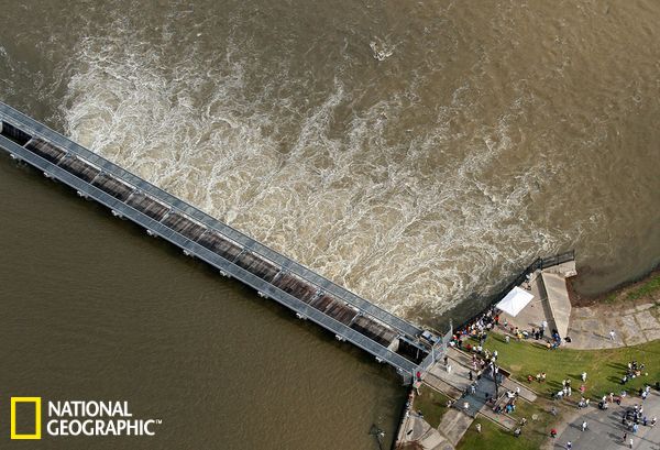
9日,美国路易斯安那州诺科,人们站在岸边,看着密西西比河洪水穿过邦卡莱泄洪道新打开的闸门。建造这个泄洪道最初用于应对1927年大洪水,将密西西比河河水分流到庞恰特雷恩湖。10日,田纳西州孟菲斯的密西西比河水位接近48 英尺(约合14.6米),距离历史最高水位不到1英尺(约合30.48 厘米)。
密西西比河及其数十个支流——形成了世界上第三大流域盆地——几个世纪以来一直洪水不断。根据西班牙探险家1543年的描述,当年爆发的大洪水导致密西西比河加宽到大约80英里(约合128公里)。正常情况下,伊利诺斯州奥尔顿附近的密西西比河最宽处可达到1英里(约合1.6公里)左右。
Weather Underground网站气象学负责人杰夫·马斯特斯指出,密西西比河从某种意义上说是两条河,上密西西比河和下密西西比河。下密西西比河起源于伊利诺斯州、密苏里州和肯塔基州边界的俄亥俄河汇合处。由于河流交汇并继续向南流动,俄亥俄河谷的大雨和融雪能够提高密西西比河洪水的可怕程度。马斯特斯表示,2011年的密西西比河洪水由明尼苏达州和达科他州的大雨和大规模融雪所致,是自上世纪初以来唯一一次波及美国中部的大洪水。
2011年密西西比河洪水
Mississippi River Flooding
Photograph by Patrick Semansky, AP
This gallery is part of a special National Geographic News series on global water issues.
People watch as floodwaters from the Mississippi River gush through newly opened gates in the Bonnet Carre Spillway in Norco, Louisiana, on Monday. The spillway, built in response to the Great Flood of 1927, diverts water from the Mississippi into Lake Pontchartrain.
At Memphis (map), Tennessee, the swollen Mississippi river crested Tuesday at nearly 48 feet (14.6 meters)—not quite a foot below the record flood level.
The Mississippi River originates at Lake Itasca in Minnesota (map) and flows about 2,300 miles (3,701 kilometers) to the Gulf of Mexico. The current flood is expected to reach Natchez, Mississippi, by May 21, and arrive in the Gulf around the end of this month. Even now residents in Arkansas, Mississippi, and Louisiana are piling up sandbags and building earthen barriers as the surge of floodwater continues its journey downriver.
The Mississippi and its dozens of tributaries, which form the world’s third largest drainage basin, have been flooding for centuries. Spanish explorers wrote about a huge flood that widened the Mississippi River to about 80 miles (128 kilometers) at one point in 1543. Under normal conditions, the river’s widest point is about a mile (1.6 kilometers) across near Alton, Illinois.
Jeff Masters, meteorological director for the website Weather Underground, noted that the Mississippi is, in a sense, two rivers—the upper and lower Mississippi. The lower Mississippi begins at the confluence of the Ohio River at the borders of Illinois, Missouri, and Kentucky (map). Heavy rains and snowmelt in the Ohio River Valley can add to Mississippi River flooding as the waters meet and continue southward.
This year’s floods were caused by intense rainfall and the melting of heavy winter snows in Minnesota and the Dakotas, Masters said. But the 2011 flooding is only the latest in a series of major floods that have soaked the country’s midsection since the early 1900s.
(Read more about how we can mitigate Mississippi River flooding in National Geographic Freshwater Fellow Sandra Postel’s most recent blog post: “Mississippi Floods Can Be Restrained With Natural Defenses.”)
—Willie Drye
Published May 10, 2011
1903 Mississippi River Flood
Photograph courtesy Detroit Publishing Company/Library of Congress
1903年密西西比河洪水
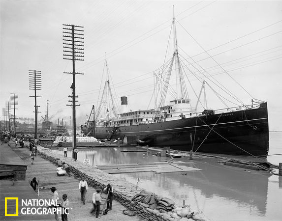
1903年3月23日,“查尔梅特”号停靠在新奥尔良一个防洪堤附近。时年2月,大雨导致俄亥俄河和下密西西比河水位暴涨。2月27日,俄亥俄河谷迎来一场暴风雨,美国气象局随后向从宾夕法尼亚州匹兹堡到俄亥俄州辛辛那提的地区发布俄亥俄河洪水预警。3月初的大雨进一步导致俄亥俄河和下密西西比河水位上升。虽然洪水几周后才能抵达墨西哥湾地区,新奥尔良还是接到警告,做好预防洪水的准备。
The steamer S.S. Chalmette sits docked near a New Orleans levee in the muddy, flood-swollen Mississippi River on March 23, 1903.
In February that year, heavy rains had caused the Ohio and lower Mississippi Rivers to steadily rise throughout the month. When another moisture-laden storm moved across the Ohio River Valley on February 27, the U.S. Weather Bureau issued flood warnings for the Ohio River from Pittsburgh, Pennsylvania, to Cincinnati, Ohio.
More heavy rains fell in early March, further swelling the Ohio and lower Mississippi Rivers. Although the floodwaters were weeks away from the Gulf Coast, New Orleans was warned to prepare for high water. (Related: “New Orleans Levees Not Built for Worst Case Events.”)
Published May 10, 2011
1927年密西西比河洪水
Mississippi’s Roaring Twenties
Photograph courtesy National Photo Company/Library of Congress
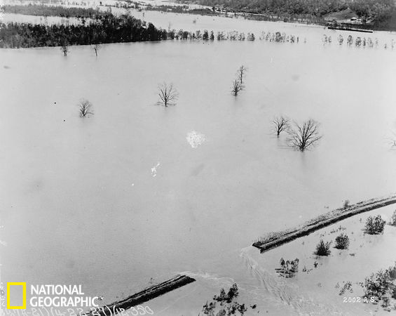
1927年4月,美国某地被密西西比河洪水淹没。这一年春季,美国7个州遭洪水袭击,大约80万人无家可归。防洪堤土崩瓦解,洪水沿支流而下,汇入密西西比河,汹涌的河水继续向南,奔向墨西哥湾。历史学家克林特·巴格利表示,他的父母仍记得当年的可怕景象,随着咆哮的洪水逼近他们位于密西西比州的家,狗开始狂吠,声音非常恐惧。
截至4月末,洪水水位已经危及到保护新奥尔良的防洪堤的安全,几周之后,防洪堤迎来最大洪峰。4月29日,美国陆军工兵部队用炸药在新奥尔良南部的防洪堤炸出一个1500英尺(约合457米)长的口子,进行泄洪,缓解新奥尔良其他防洪堤的压力。
密西西比档案与历史部门的历史学家格拉迪·霍维尔指出,这场大洪水造成大约10亿美元经济损失,当时的国家债务为30亿美元。可怕的洪水导致美国社会和经济发生巨变,促使美国政府启动密西西比河洪水控制计划,主要就是建造和维护防洪堤。这一计划一直延续至今。
An unidentified region lies under Mississippi River floodwaters in April 1927. During the spring of 1927, the “granddaddy” of all floods inundated parts of seven U.S. states and left about 800,000 people homeless.
Levees started failing as the floodwaters raced down tributaries into the Mississippi River and surged toward the Gulf of Mexico. Historian Clint Bagley said his parents recalled dogs starting to bark as roaring floodwaters approached their Mississippi home.
By late April floodwaters threatened to top the levees protecting New Orleans, yet the worst of the flood was still several weeks away. On April 29 the U.S. Army Corps of Engineers used dynamite to blow a 1,500-foot (457-meter) gap in a levee south of New Orleans to relieve pressure on the rest of the city’s levees.
Historian Grady Howell of the Mississippi Department of Archives and History noted that the “staggering” cost of the Great Flood was about a billion dollars—at a time when the national debt was three billion.
The flood caused dramatic social and economic upheaval, Howell said, and prompted the U.S. government to begin the ambitious Mississippi flood-control program—mainly the building and maintaining of levees—that continues today.
Published May 10, 2011
1937年密西西比河洪水
Saving Cairo, 1937
Photograph courtesy Farm Security Administration/Library of Congress
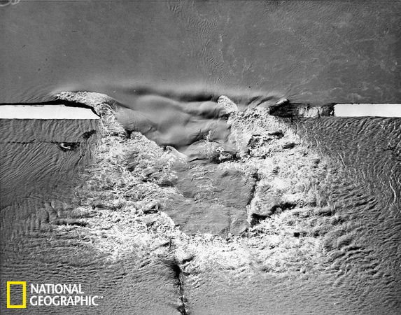
1937年密西西比河发生洪灾,图为洪水溢过被炸毁的防洪堤以挽救伊利诺伊州的开罗。美国国民警卫队不得不防范武装起来的愤怒农场主,他们想阻止破坏堤防的行动,以免农田遭受洪水灾害。
在这一年一月大雨和融雪导致俄亥俄州和密西西比河上游河水猛涨,堤坝告急,在一月底决口。田纳西州孟菲斯和其它城市被水淹没,国民警卫队士兵在一些地方进行巡逻,以防止洪水毁坏堤防并转移人员。
历史总是重复再现,2011年5月2日,当美军工程兵爆破一个土堤防以分流不断上涨的河水,将开罗得洪水引入密苏里州的农田。美联社报道说,上涨的俄亥俄河水在当日下午攀升至61.2英尺(18.6米),打破了1937年59.5英尺(18.1米)的记录。
Floodwaters race over a levee that was dynamited to save Cairo, Illinois, during a 1937 Mississippi River flood. U.S. National Guard troops had to ward off armed and angry farmers who wanted to prevent the levee’s destruction from flooding their croplands.
In January that year heavy rain and snow swelled the Ohio and upper Mississippi Rivers, and levees were strained to bursting by the end of the month. Memphis, Tennessee, and other cities were flooded, and National Guard troops were on patrol in some places to prevent people from destroying levees to divert floodwaters away from their properties.
History repeated itself on May 2, 2011, when the U.S. Army Corps of Engineers blasted open an earthen levee to divert rising floodwaters away from Cairo and into Missouri farmland. The swollen Ohio River had climbed to 61.2 feet (18.6 meters) that afternoon, breaking the 1937 record of 59.5 feet (18.1 meters), the Associated Press reported.
Published May 10, 2011
1983年密西西比河洪水
Mississippi Manor, 1983
Photograph by Nathan Benn, Corbis
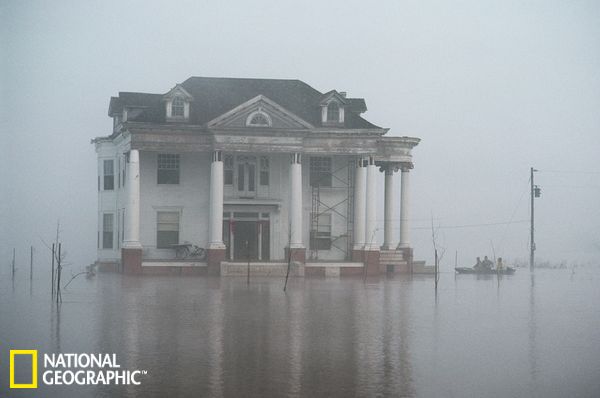
1983年3月,密西西比州格林古德,晨雾笼罩着一座19世纪建造的房屋,四周被洪水包围。当时,下密西西比河支流亚罗布沙河爆发洪水。1983年的洪水是1927年以来下密西西比河爆发的规模第二大洪水,经济损失估计达到1570万美元,沿河一带的工业设施、船坞设施和农田受灾最为严重。
Early morning fog shrouds a 19th-century house standing amid floodwaters in Greenwood, Mississippi, in March 1983. The house was a victim of floods in the Yalobusha River, a tributary of the lower Mississippi River.
The 1983 flood was the second severest flood on the lower Mississippi since 1927. Costs were estimated at U.S. $15.7 million, mostly from damaged river industries, docking facilities, and widespread agricultural losses.
Published May 10, 2011
1993年密西西比河洪水
Sandbagging the Mississippi, 1993
Photograph by Jodi Cobb, National Geographic
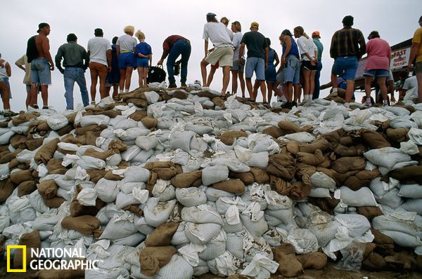
1993年,密西西比河一支流爆发洪水,爱荷华州得梅因的居民站在沿岸的沙袋堆上,看着可怕的洪水。这一年的夏季,高压天气系统(有时在东岸形成)和强风急流席卷南部。多种因素共同作用,导致夏季的暴风雨留在原地,而不是像正常情况下那样向东移动。春季的大雨已经导致中西部地区泡在水里,让创纪录的夏季大雨没有“出路”,致使上密西西比河及其支流水位暴涨,中西部地区遭受洪水袭击。
7月初,美国9个州部分地区均被洪水淹没,爱荷华州部分地区几个月内的降雨量超过3英尺(约合1米)成为受灾最严重的地区之一。得梅因居民用数千个沙袋堆起堤坝,希望能够挡住洪水。7月10日和11日,洪水涌入得梅因,电力设施、水净化厂遭到破坏,大量房屋和店铺被洪水吞噬。
Residents of Des Moines, Iowa, stand on piles of sandbags during a 1993 flood along a tributary of the Mississippi River.
As the spring of 1993 turned to summer, a high-pressure weather system that sometimes forms off the East Coast appeared, and upper-level winds known as the jet stream swung south. The combination of factors held summer storms in place instead of allowing them to be swept eastward, as they normally are.
Heavy spring rains had already saturated much of the Midwest, so there was no outlet for the record-setting summer rainfall, which drenched the Midwest and the upper Mississippi River and its tributaries.
By early July, parts of nine U.S. states were under water. Iowa—where some places saw more than three feet (about a meter) of rain in only a few months—was one of the hardest hit.
Des Moines residents piled up thousands of sandbags, hoping to keep the flooded Raccoon and Des Moines Rivers at bay. But during the weekend of July 10 and 11, floodwaters surged into the city, knocking out power and the city’s water-purification plant as well as flooding homes and businesses.
Published May 10, 2011
美国密西西比河启闸分洪 影响25000人及万余房屋
中新社纽约5月14日电 (记者 孙宇挺)由于美国密西西比河水位不断上升,美国陆军工程兵团14日下午升起了位于路易斯安那州州府巴吞鲁日市附近莫干扎泄洪道的闸门,将密西西比河高涨的洪水引入阿查法拉亚河流域的农田和牧场。
据称预计将会有25000人和11000座房屋受到影响,预计水淹区域或达3000平方英里,最深处有25英尺。这是莫干扎泄洪道自1973年以来首次开闸泄洪。
这一分洪措施将减轻密西西比河已然高涨的水位和沿岸堤坝的压力,以便能让洪水顺利通过巴吞鲁日、新奥尔良以及附近的一些化工、炼油工厂区,不致对这些地方造成毁灭性灾难。
疏散工作这些天来一直都在阿查法拉亚河流域的城镇中进行着,同时为了保护这些城镇免受洪水侵袭,大量防洪沙袋和阻隔物也被调运安放。
莫干扎泄洪道是密西西比河四个泄洪道之一,建于1953年,在1973年曾被打开过。过去数周,暴雨反复袭击了密西西比河部分流域。沿河各州在为超出警戒水位而做出准备的同时,开闸泄洪的方案也一直处于争论中。
“我们已经调动了所有可以动用的防洪措施和手段,”美国陆军工兵团密西西比河流域的负责人沃尔什少将对媒体表示,此前这位负责人表示将“以生命安全为第一考量”。
根据美国气象局的测量,周六下午,密西西比河洪水的洪峰接近阿肯色州的海伦娜,洪峰高度为56.4英尺,高于洪水位12.4英尺。
陆军工程兵团并表示,周日可能还将打开其他区域的泄洪闸。
密西西比州洪峰直逼历史纪录 威胁沿岸多地
美国密西西比河沿岸多地遭洪水威胁:孟菲斯洪水70年一遇;伊利诺伊和密苏里州已遭洪水;阿肯色、密西西比和路易斯安那州超危险水位。图为5月11日维克斯堡洪峰直逼纪录。
密西西比州维克斯堡洪峰直逼历史纪录
工人在洪水中用船只运送沙袋
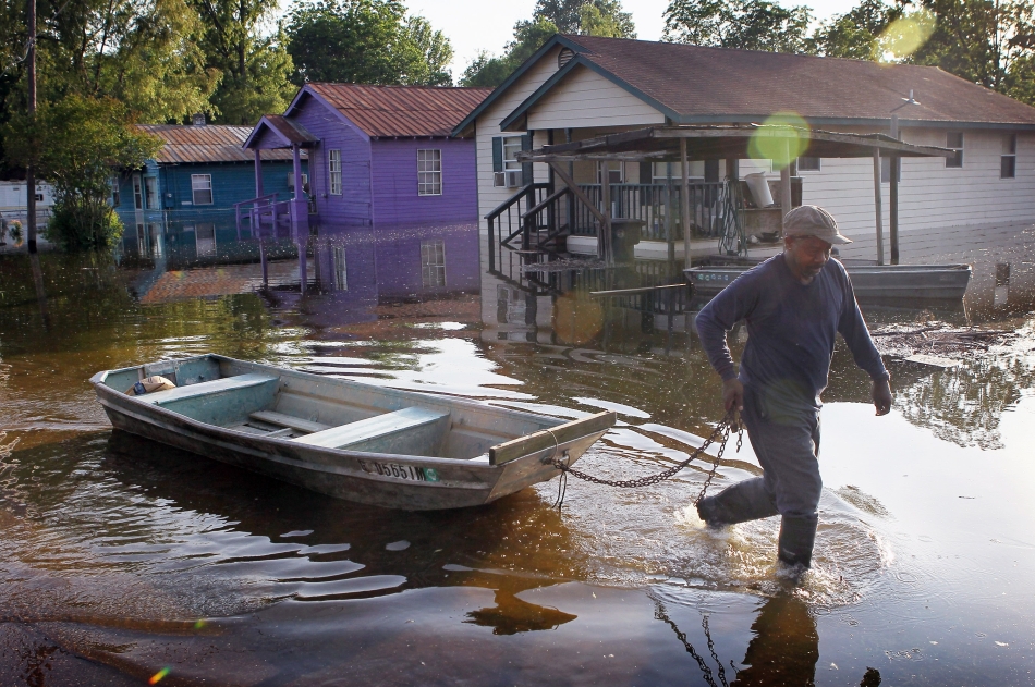
一位居民拉船走过被洪水淹没的街道

孟菲斯民房遭洪水袭击
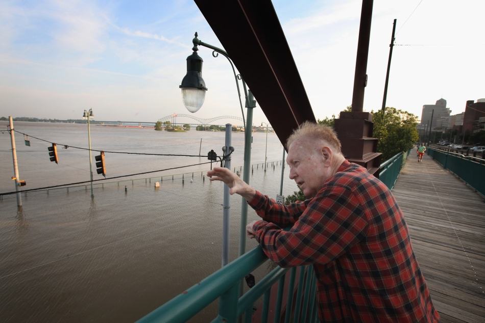
孟菲斯一位居民望着泛滥的洪水
美国在密苏里州河堤炸出3公里缺口防洪
中国新闻网/
美国在密苏里州河堤炸出1.1万英尺缺口防洪
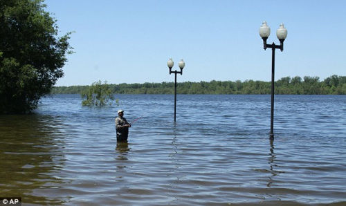
当地居民在河里钓鱼。
为防止洪水进一步威胁伊利诺斯州凯罗城,美国陆军工兵部队(the Army Corps of Engineers)5月2日傍晚在密苏里州怀亚特(Wyatt)附近一处河堤上炸出一个1.1万英尺(3352.8米)的缺口。
消息称,美国陆军工兵部队的这一举动牺牲了河堤附近13万英亩的土地和100处房子,但预计能保护居住在俄亥俄河和密西西比河交汇处的2800名伊利诺伊州居民。
怀亚特的居民5月3日凌晨聚集在河堤旁围观黑褐色的河水,牛群在河堤的斜坡处吃草,国民卫队的士兵在附近巡逻。
一个曾在河堤附近拥有1千英亩土地的农夫表示,自己的土地现在都在水下了,但他的家保住了,“这个洞改变了我们的生活,我也对那些同样失去土地或房子的人表示同情。”
一些怀亚特的居民5月2日晚观看了爆炸的过程,他们表示当时的场面非常壮观,家里的窗户被震响许多次。
国家气象局表示,这次的爆炸对于伊利诺斯州凯罗城的水位控制起到了作用。在进行爆破前,该地区水位是61.72英尺而且还在上升,但5月3日早晨测量的水位是60.62英尺,并且预计到5月7日会下降到59.4英尺。
美国陆军工兵部队官员表示,这次的爆破对于降低凯罗城和肯塔基州北部一个河堤的水位起到作用,预计到5月4日能够降低4英尺左右的水位。